Fred and his brother are researchers that study the migration patterns of birds. Recently, Fred wanted to build a small, solar powered, light-weight unit that can report its position at least once a day. In addition, it would need to be under 13 grams and rugged enough to be strapped to a large bird for an extended period of time.

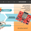
This Swainson Hawk is donating its time to test the prototype.
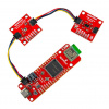
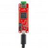
The project is based around a Telit GE865 with a 50mAh LiPo battery for power. I am sure by now you are wondering how any of this will weigh less than 13 grams? It was not easy, but Fred managed to pull it off in true hacker fashion.

SIM card and GE865
In order to keep the weight down, Fred did not use a SIM card holder. Instead, he trimmed some of the plastic around the copper contacts, then soldered all of the capacitors directly to the SIM card. It is VERY easy to ruin a SIM card by soldering to it and Fred destroyed a bunch of cards trying figuring out the best way.


Even the antenna was stripped down to the bare essentials.
For power, Fred used a 50mAh battery, a MAX1555 battery charger, and a small solar cell. He also had to build a custom enclosure to keep the device safe for the bird and the electronics protected from elements. Fred melted sheets of PETG plastic in an oven, then injected it into a custom made plug. Next, he painted the enclosure, installed the electronics, battery, and mounted the solar cell on top with silicone. The unit then was strapped to the bird like a backpack. The final unit weighed in at amazing 11 grams, which is a hair heavier than a poker chip!
So how does he find the position of the bird? Fred runs a python script on the GE865, which puts the unit into sleep mode and wakes it up to conserve battery power. The script takes this information and puts it into an SMS (text message) which is sent to a GE865 Eval Board base station. In order to triangulate position, he runs a report to see what towers are within range. He then has a program that pulls the messages off of the eval board and keeps a copy on his computer. Once he has the cell tower data he uses it to triangulate the position of the unit through a database of GSM tower longitude/latitude positions.
The triangulation process is not very accurate (within a few miles), but for Fred's purpose it is close enough. All they need to see are migration patterns, they don't care to know the exact path. So far, his prototypes are working well on the Swainson's Hawks located in the US. In the next month or so, the birds will be migrating down to Argentina!

Maybe conductive epoxy would have worked better for the electrical connections to the sim card. This stuff for example:
http://webvia.techni-tool.com/VIA/viaImagePageIndex.jsp?row=0&pgName=viaListProducts.jsp&searchText=epoxy&modifier=SEARCH&reqTitle=TITLE_VIASEARCHRESULT&newWindow=Y
Missed opportunity to integrate with Twitter.
Tracking those tweets would be amazing.
in theory if every thing is sent down to the base station, as described above. It would be quite simple to add some code to post the twitter updates. With out changing any thing on the birds
I would love to have the data post to twitter. The issue is that this data is for my brothers PHD studies and these academic guys guard there data closely.
Fred, is this configuration still working?
Hello Fred, I'm very interest in your work. Are you still developing these kind of device? Then, can you please mail me?
Great project Fred! Where did you find the solar cells?
We have several methods to catch the birds. For the chicks we climbed the tree's and take them out of the nest in order to band, weigh, and measure them before returning them to the nest. Depending on how mature the chick is we can attach a tracking device as well. For the adults we usually use a Great Horned Owl which is a natural predator to make them mad. Yes, a Great Horned Owl is illegal to own but this one had an accident with a power line so he cant be released into the wild and my brother does have the permits for him. We take the owl and put him on the ground next to the nest. Then we string up a net next to the owl similar to how you would do a volleyball net except that this one goes all the way to the ground and about 8' tall. Since the hawk is upset at the owl's presence they tend to swoop down and try to scare the owl away and get caught in the net in the process. If you are interested you can read more about the study at www.swainson.org.
Hi Fred where did you buy the solar cell you used?
The solar cell in these pictures was from Ebay and the vendor disappeared a long time ago. The square size of that solar cell was not ideal since it gave a lip for the bird to grab onto. I was never able to find exactly what I wanted from an off the shelf product so now I have all my solar cells custom made. You can take a look at www.solarbotics.com for some good solar cells though. They don't have a lot of size options but the ones I have tested are good quality
"For the chicks we climbed the tree's and take them out of the nest in order to band, weigh, and measure them before returning them to the nest."
Sounds like a job for Keith Stone. ;)
how did u catch the hawk?? ^^
will their friends peck the device away?
Duck antenna? More like a hawk antenna!
LOL ;)
This is too cool, the people demand a website! :)
Thanks for the comments everyone! I happen to be a pilot and I am familiar with the rule that has been put into question. I feel comfortable that I am not violating any laws by putting them on birds.
Someone commented that this must not be rural. Actually they were deployed in Butte Valley, California which is about as rural as you can get. I timed the transmit to be at times of day that the birds are likely to be in the air which increases the odds of seeing a tower.
The epoxy idea was great and I will give that a try.
Great job Fred! I was wondering if the cell-tower databases you're using are OpenSource/freely-available? In either case, could you state your source for the data? Thanks.
;-> (cjh)
The database I am using is not open source. The database also triangulates wifi signals with a very high degree of precision if you are in a more urban area. I think a lot of interesting projects could be built on this and I am currently developing a few more things. The that company developed this database usually licenses it to companies like Microsoft so I am very lucky to have access to it.
I forgot to mention that it is www.navizon.com that is helping me triangulate the position. If you want an open source version you can use www.opencellid.org but it has a lot of holes in it from what I can see.
sigh I can't even get gsm service on my own driveway. I had a project that could have been done easily and cheaply with GSM messaging. I ended up submitting a prototype with a Orbcom sat link.
Priced myself out of range.
I suppose this exercise didn't take place anywhere rural.
I'm very interested in the solar powered charging part of the device. What solar cells was used? Trickle charge or "full charging"? Is there a circuit diagram or breakout board for this?
I used the MAX1555 charger with a 5.5 volt 35 mah solar cell. Since my battery is only 50mah it gets charged pretty fast. I used the MAX1555 circuit diagram which can be found here.
http://www.sparkfun.com/datasheets/Components/MAX1551-MAX1555-1.pdf
Thanks Fred, great work!
Would you like to share a circuit diagram and/or a picture of the connection between the solar cell and the Max 1555?
Is the solar cell connected directly to the charger or are other components involved? I've read that solar cells are a bit tricky when it comes to balancing current and voltage...
The solar cell is connected directly to the MAX1555 with no other hardware. The diagram is posted in the data sheet for the charger and this is what I used. However soldering such a small package was difficult so I put the charger on a breakout board which Sparkfun sells. The MAX1555 has low voltage limits built in so if the solar cell isn't generating enough voltage it wont try to charge. I used a monocrystalline solar cell for this because its the only thing small enough that put out enough voltage with high enough current. I actually have a thin film solar cell which is 2.5 grams lighter but its 3 times the size which is big enough to interfere with the birds ability to regulate temperature. So I had to accept the higher weight of the smaller cell to limit the impact on the bird.
what solar cell did you use? model number/link? great project btw!
"a small, solar powered, light-weight unit that can report its position at least once a day."
Sounds like a job for QRSS. There's a record for a 40 mW transmitter reaching 80 km away, but you can only send something like 1 bit per second. :D
This is the coolest SF project post I've seen to date!
Very cool! I wonder if this violates the FAA's no airborne cellular communication law.
The FAA rule on cell phone use specifically refers to "aircraft" and is intended, at least according to Wikipedia, to avoid interfering with flight control systems. EMI is probably not a big problem when flying on a bird, and I doubt that a wild bird is an aircraft.
Somewhere I heard that a cell phone operating at ten-thousand feet would cause problems for the towers because many towers would see it at the same time and they would get confused as to which one should talk to it. But there may be safeguards against that, and birds don't fly at 10,000 feet anyways.
I was wondering the same thing... for reference, from CFR Title 47, Part 22, Subpart H:
? 22.925 Prohibition on airborne operation of cellular telephones.
Cellular telephones installed in or carried aboard airplanes, balloons or any other type of aircraft must not be operated while such aircraft are airborne (not touching the ground). When any aircraft leaves the ground, all cellular telephones on board that aircraft must be turned off. The following notice must be posted on or near each cellular telephone installed in any aircraft:
?The use of cellular telephones while this aircraft is airborne is prohibited by FCC rules, and the violation of this rule could result in suspension of service and/or a fine. The use of cellular telephones while this aircraft is on the ground is subject to FAA regulations.?
The question is... is a bird "any other kind of aircraft"?