- Home
- Product Categories
- Wireless Kits
- SparkFun RTK Surveying Kit


SparkFun RTK Surveying Kit
The SparkFun RTK Surveying Kit has everything you need to get centimeter level global positioning measurements using GNSS RTK. We've created a handy carrying case to protect the most expensive bits, allowing you to quickly attach the L1/L2 antenna and RTK Surveyor housing to the pole or tripod of your choice. The kit includes all the antenna bits, cables and chargers you need to jump right into the field.
The RTK Surveyor is a Bluetooth® enabled multi-band GNSS receiver based on the ESP32 from Espressif and the ZED-F9P from u-blox. Flip the switch and you'll have 300mm approximate accuracy out of the box and 18mm accuracy with RTCM corrections. This kit provides the L1/L2 antenna, adapters, interface cables, and chargers needed for general GNSS use.
The RTK Surveying Kit works with common GIS software for Android and iOS including SW Maps Android / iOS, Field Genius, SurvPC, Survey Master, Vespucci, QGIS, QField, and any GIS software that supports NMEA over Bluetooth.
We generally recommend using your cellular phone as the radio backhaul for RTCM but you can also use your own, higher power radios as long as they support 57600bps. We also recommend logging all data to your phone over Bluetooth. This is as simple as checking a box within SW Maps. But if you prefer to do long surveys, or need to deal with RAWX measurements where a phone will not be present, a microSD card should be purchased (any size up to 32GB).
Please keep in mind that you will need to provide your own mono-pod or tripod as well as a cell-phone type holder for securing the RTK Surveyor to your mono-pod or tripod. We've found this style clamp and this style clamp work well. Your mileage may vary.
Note: The L1/L2 antenna has a 5/8" thread which will fit most surveying platforms. The kit includes a 5/8" to 1/4" adapter as well which will fit most camera mono-pods and tripods. You may need additional adapters for your specific equipment.
Important: The SparkFun RTK Surveyor is not designed for permanent outdoor mounting. Please mount the L1/L2 antenna (which we've had outside constantly for over three years in Colorado UV) outside with a SMA cable running to the RTK Surveyor that is located inside or protected from the elements. See Creating a Permanent Base for more information.
Supported GIS Data Collector Software:
- SWMaps (Android and iOS)
- Field Genius
- SurvPC
- Survey Master
- Vespucci
- QGIS
- QField
- Any GIS software that uses Bluetooth SPP or BLE
GNSS Receiver: ZED-F9P
- Concurrent reception of GPS, GLONASS, Galileo and BeiDou
- Receives both L1C/A and L2C bands
- Current: 68mA - 130mA (varies with constellations and tracking state)
- Time to First Fix: 25s (cold), 2s (hot)
- Max Navigation Rate:
- PVT (basic location over UBX binary protocol) - 25Hz
- RTK - 20Hz
- Raw - 25Hz
- Horizontal Position Accuracy:
- 2.5m without RTK
- 0.010m with RTK
- Max Altitude: 50km (31 miles)
- Max Velocity: 500m/s (1118mph)
Bluetooth® Transceiver: ESP32 WROOM
- Xtensa® dual-core 32-bit LX6 microprocessor
- Up to 240MHz clock frequency
- 16MB of flash storage
- 520kB internal SRAM
- Integrated 802.11 BGN WiFi transceiver
- Integrated dual-mode Bluetooth® (classic and BLE)
- Hardware accelerated encryption (AES, SHA2, ECC, RSA-4096)
- 2.5 µA deep sleep current
Overall Device
- Internal Battery: LiPo 1000mAh with 500mA charging
- Radio Port: 3.3V TTL Serial (57600bps RTCM TX/RX, configurable)
- Data Port: 3.3V TTL Serial (460800bps NMEA, configurable)
- Toggle switch controls
- Weight: 162g (entire device including battery)
- Dimensions: 132mm x 101mm x 32mm (5.2in x 3.9in x 1.2in)
- 1x Qwiic Connector
- 1x microSD Socket for optional logging
- Works with common GIS software including: SW Maps, SurvPC, Field Genius, et al.
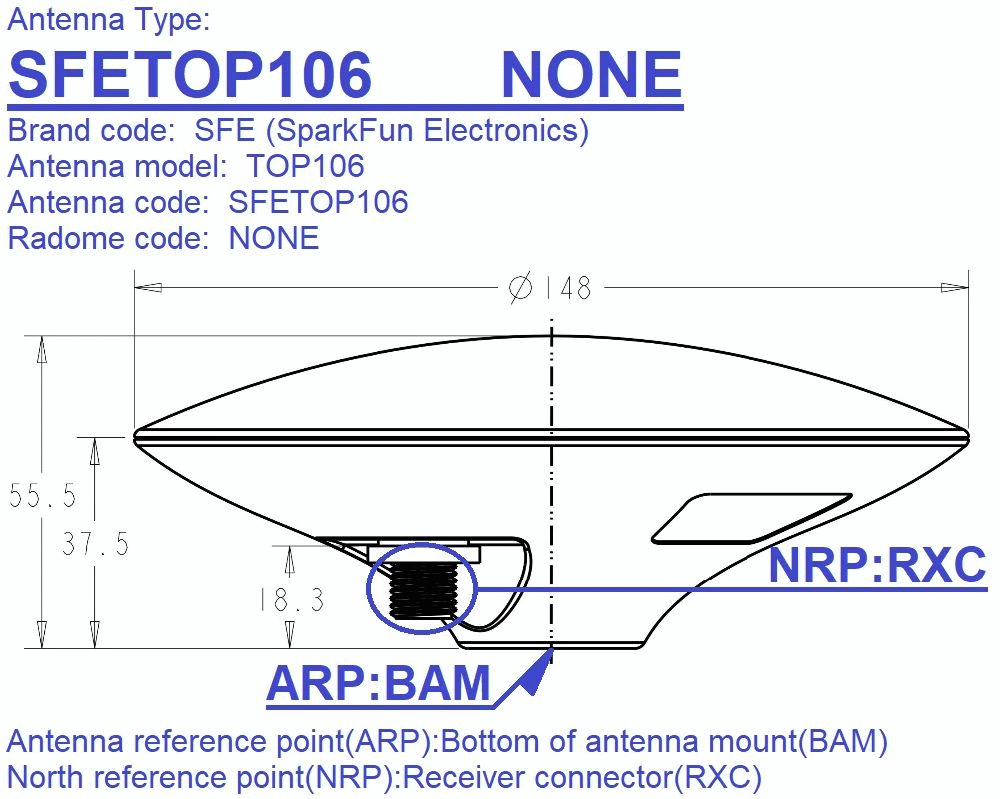
GNSS Multi-Band L1/L2 Surveying Antenna
- Gain: ≥5dBi
- LNA Gain: 40dB
- Reception Frequencies
- L1: 1555 to 1615MHz
- L2: 1198 to 1278MHz
- 50 Ohm Antenna Impedance
- Overall antenna weight: 335g
- Bare antenna element weight (including MMCX connector, with RF shield): 160g
- Dimensions: 148 x 55mm
- Waterproof IP67
- Connector: Female TNC
- Antenna NGS Calibration Data:
- Reference Drawing including North Reference Point
- ANTEX
- ANTINFO
- Hookup Guide
- RTK Product Manual
- Schematic
- TOP106 GNSS L1/L2 Multiband Antenna
- Firmware Repo
- Hardware Repo
SparkFun RTK Surveying Kit Product Help and Resources
How to Build a DIY GNSS Reference Station
October 15, 2020
Learn how to affix a GNSS antenna, use PPP to get its ECEF coordinates and then broadcast your own RTCM data over the internet and cellular using NTRIP to increase rover reception to 10km!
SparkFun RTK Surveyor Hookup Guide
December 3, 2020
Learn how to use the enclosed RTK Surveyor product to achieve millimeter level geospatial coordinates.
How to Upgrade Firmware of a u-blox GNSS Receiver
March 26, 2021
A few steps and you'll upgrade to the latest features on a u-blox GNSS receiver.
Core Skill: DIY
Whether it's for assembling a kit, hacking an enclosure, or creating your own parts; the DIY skill is all about knowing how to use tools and the techniques associated with them.
Skill Level: Rookie - Basic hand tools are required and instructions will allow more freedom. You may need to make your own decisions on design. If sewing is required, it will be free-form.
See all skill levels
Core Skill: Programming
If a board needs code or communicates somehow, you're going to need to know how to program or interface with it. The programming skill is all about communication and code.
Skill Level: Competent - The toolchain for programming is a bit more complex and will examples may not be explicitly provided for you. You will be required to have a fundamental knowledge of programming and be required to provide your own code. You may need to modify existing libraries or code to work with your specific hardware. Sensor and hardware interfaces will be SPI or I2C.
See all skill levels
Core Skill: Electrical Prototyping
If it requires power, you need to know how much, what all the pins do, and how to hook it up. You may need to reference datasheets, schematics, and know the ins and outs of electronics.
Skill Level: Rookie - You may be required to know a bit more about the component, such as orientation, or how to hook it up, in addition to power requirements. You will need to understand polarized components.
See all skill levels
Comments
Looking for answers to technical questions?
We welcome your comments and suggestions below. However, if you are looking for solutions to technical questions please see our Technical Assistance page.
Customer Reviews
4.6 out of 5
Based on 9 ratings:
1 of 1 found this helpful:
works great after upgrading the firmware
The Surveying kit worked great after updating the firmware. When I received it it was at version 2.2 which meant that internet was not working. I tried using the firmware update tool for windows, and although I could talk to the unit through the port, make changes, etc the firmware upgrade refused to work (Windows 11) . After trying for several hours I gave up and tried doing the firmware upgrade using my Mac Laptop. That worked, and once the firmware was upgraded the full functionality was there and it worked great.
I used it to serve the locations of several field telescopes in Southern Arizona and it worked great despite the fact that the telescopes were surrounded by mountains. Took about 10 minutes to get to 10mm resolution.
So Pros: works great once you get the firmware upgraded. All the instructions and quick setup are written assuming the firmware is upgraded, so if you can't upgrade the firmware, the quick start instructions do not make any sense. There are no instructions to use the device under the old firmware, making it a bit frustrating.
But overall a very good product for the price once you spend a day to so getting it to work properly and be configured properly. The instructions work perfectly if the firmware has been upgraded.
2 of 3 found this helpful:
Exceptional piece of equipment
I've been messing around with GPS surveying since the early 1990s, when Selective Availability was still a thing. Getting highly accurate absolute positional data has always been a challenge, one that is generally only solved by the application of large amounts of money. This kit removes that barrier! I use it in conjunction with SW Maps, a great free app (Android only, but no one who's serious about technology uses an iPhone anyway), and the NTRIP Client from Lance Lefebure (also free). I use it for RTK via an NTRIP server to give me corrections, but I'm considering getting a second unit to act as a base station for independence from corrections that are potentially over long baselines.
Very easy to set up, especially if you follow the Sparkfun guides. I added two phone clamps, and survey pole, and a survey level bubble. All up I probably have about $800 invested, which is amazing for the degree of absolute accuracy provided by the system. I pull the exported data into either QGIS or Autocad, depending on project needs. The workflow is simple.
Anyone who is interested in surveying accurately can bring this into their lives and perform great surveys with a minimal (equipment) learning curve - learning about surveying is another topic, but you can get some pretty good tuition online from any number of sources.
Up and running in minutes
RTK Surveying is a cheap and ideal GNSS RTK device to test the MyCumulus Android app. Switching on, Bluetooth pairing, selecting the SparkFun RTK Surveying device in MyCumulus... and within a minute we got centimeter precision thanks to the NTRIP client in MyCumulus, streaming the RTCM correction data over Bluetooth. Especially as software developers, we don't need an expensive device that basically does the same as the SparkFun RTK Surveying.
todo esta excelente
recibi conforme y vere pronto altas precisiones en mi proyectos personales.
Very Accurate
To test its accuracy I took it to a geodetic marker nearby and used free RTK from MACORS to get a position fix. It hit the location pretty much dead on, within the accuracy of the placement of the geodetic marker, plus continental drift since the marker was measured 25 years ago. Easily 10x more accurate than a standard GPS or phone.
It also works well with various PPP services thanks to the antenna being in their databases so they can get very accurate estimates of position, often coming back with 95% certainty of the latitude and longitude within 1cm.
That said, it did need a bit of electrical engineering to get it started, as it initially couldn't see any satellites. On debugging, I found a solder glob between the antenna and ground. Once that was removed it works like a charm.
There's a lot more that could be improved with it, and I expect it'll continue to get better as the firmware is getting regularly updated. One thing it could use is better power draw management when first plugged into a computer as sometimes it draws too much and shuts down the USB port. It would also be nice if it interfaced more directly with the iPhone's location services and/or if there were more apps that worked with it, or if SW Maps (or the internal firmware) knew about this particular antenna so it could do an even better job of giving accurate results.
0 of 1 found this helpful:
I think I got a bad one.
Oh my, where do I even begin with this wonderful RTK-Surveyor? I mean, I just received it, like so recently, and I'm already having a blast with it. First of all, let's talk about the antenna. It's such a pleasure when it decides to work, but unfortunately, it's as sporadic as the weather these days. So, I did what any normal person would do and went to their forum for help, only to find out that their chat page is just a never-ending loop of links. Joy! But don't worry, Sparkfun came to my rescue with their non-helpful response, followed by an email that just confirmed what I already knew - the antenna was intermittently faulty.
But wait, there's more! Turns out the SD card slot on the board has some special, unique design that matches up perfectly with the case - so perfectly, in fact, that I lost an SD card inside the case. No big deal, right? Just another little feature to keep me on my toes.
So, here I am with a unit that I had to fix myself by buying a replacement antenna cable and digging out an SD card. But hey, it's all worth it when it decides to work and I get to enjoy playing with it. Because, let's be real, who doesn't love fixing their own gadgets? It's such a joyous experience.
accurate, well documented
came for the documentation, stayed for the ease of use and accuracy.. in a world where there really aren't super cheap options for this kind of thing, i've found that this is one of very few "affordable" options (other than the unbundled board versions from sparkfun, emlid m2, etc..).. really like the switches, leds and overall ease - using a cellphone and new york state's ntrip (many states apparently will give you ntrip correction data for the cost of signing up..) we were able to get to cm accuracy with a cellphone and no sweat.. followed mounting product suggestions and got a jaunty surveying rover pole out of them..
Very well designed and engineered device with amazing resolution.
Took a bit to download most recent software. I think instructions can be improved but in general excellent device.
No Surprise, It works great !
Product is providing the expected features and specs Easy implementation in few minutes Very satisfied of this purchase
I've tried "Technical Assistance" page and found that after registering and logging in that I am unable to post any questions to "Technical Assistance." I would like to know what happed to the local network that was in the 2.2 firmware and isn't in the 3.0 and 3.1 firmware and why there are many 404 pages in the RTK user manual?
There are two places where you can get help: the forum and the repo issues. The repo for issues is the best place for reporting 404 pages on the RTK manual. This is the first I'm hearing of any problems.