- Home
- Product Categories
- GPS Boards
- SparkFun RTK Facet L-Band


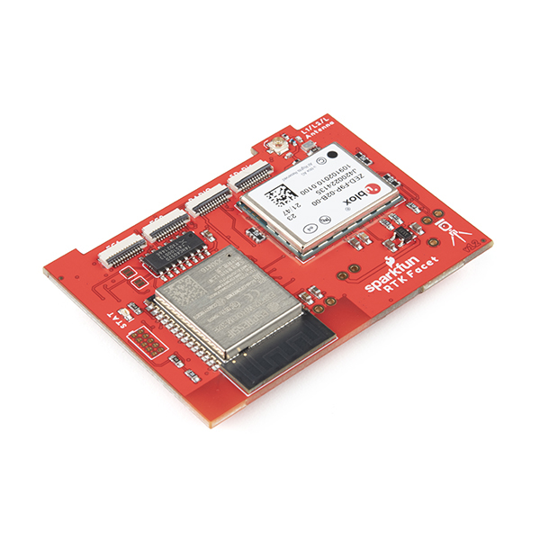
SparkFun RTK Facet L-Band
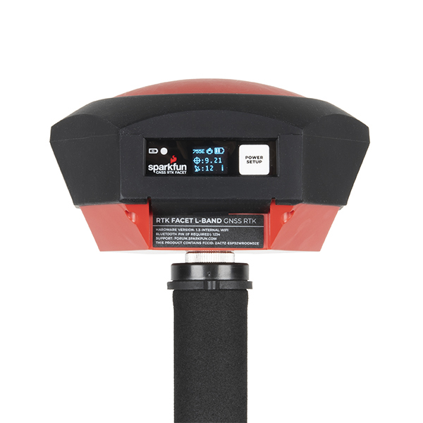
Designed and manufactured in Boulder, Colorado, USA, the SparkFun RTK Facet L-Band is your one-stop shop for high precision geolocation and surveying needs. For basic users, it’s incredibly easy to get up and running; for advanced users, the RTK Facet L-Band is a flexible and powerful tool. With just the press of a button, the RTK Facet L-Band is the fastest way to take centimeter-grade measurements. With built-in corrections, 14mm Real Time Kinematic fixes are less than a minute away. By connecting your phone to the RTK Facet L-Band over Bluetooth®, your phone or tablet can receive the NMEA output and work with most GIS software. This is exactly how $10,000 surveying devices have been operating for the past decade - we just made it faster, more precise, and a lot more economical.
The RTK Facet L-Band works with common GIS software for Android and iOS including SW Maps Android / iOS, Field Genius, SurvPC, Survey Master, Vespucci, QGIS, QField, and any GIS software that supports NMEA over Bluetooth.
The RTK Facet L-Band utilizes corrections from u-blox's PointPerfect service broadcast from a geosynchronous Inmarsat satellite. The only setup required is a WiFi SSID and password. Once entered, the device will provision itself and periodically (once a month) update the decryption keys necessary to use the PointPerfect service. The price of the RTK Facet L-Band includes a 12-month subscription. Additional years of service can be purchased.
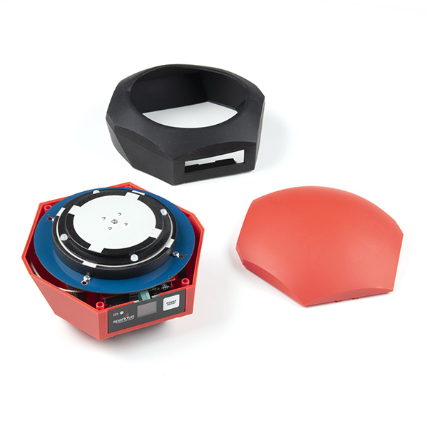
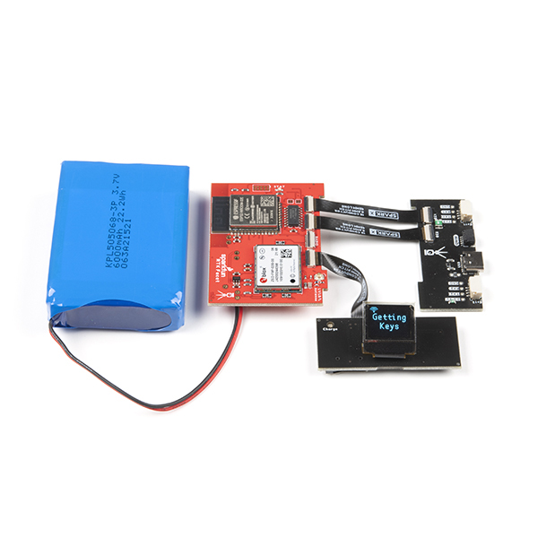
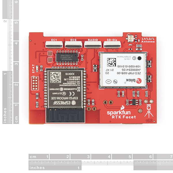
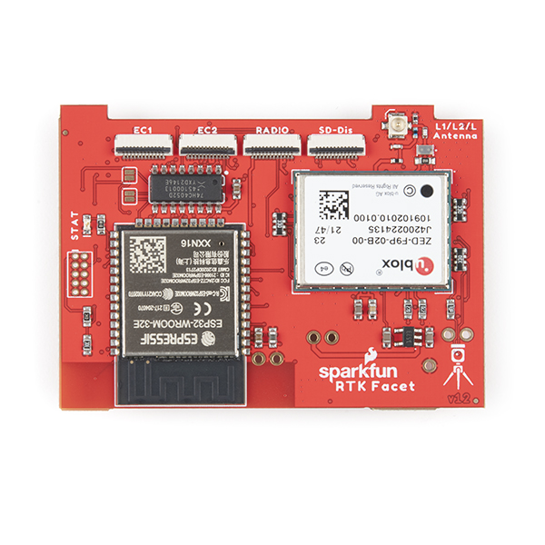
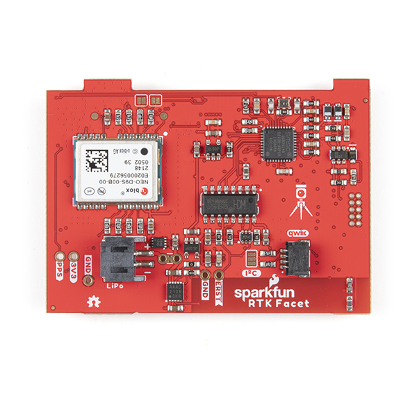
Under the hood of the SparkFun RTK Facet L-Band is an ESP32 WROOM connected to a ZED-F9P GNSS receiver, a NEO-D9S L-Band receiver (for corrections), and a variety of peripheral hardware (LiPo fuel gauge, microSD, etc). Additionally, housed under the dome of the RTK Facet L-Band is a surveyor grade L1/L2/L-Band antenna. This antenna is a unique combination of elements designed to receive the GNSS signals (L1/L2) alongside the 1.55GHz PointPerfect corrections. The built-in antenna has an ARP of 69mm from the base to the measuring point of the L1 antenna and an ARP of 68mm to the measuring point of the L2 antenna. The RTK Facet L-Band is programmed in Arduino and can be tailored by you to fit whatever your needs may be.
This device can be used in five modes:
- GNSS Positioning (~30cm accuracy) - also known as 'Rover'
- GNSS Positioning with RTK L-Band (1.4 to 6cm accuracy) - also known as 'Rover with L-Band RTK Fix'
- GNSS Positioning with RTK (1.4cm accuracy) - also known as 'Rover with RTK Fix'
- GNSS Base Station
- GNSS Base Station NTRIP Server
At Power On the device will enter Rover or Base mode; whichever state the device was in at the last power down. When the POWER/SETUP button is pressed momentarily, a menu is presented to change the RTK Facet L-Band to Rover or Base mode. The display will indicate the change with a small car or flag icon.
In Rover mode the RTK Facet L-Band will check if WiFi is available and update any L-Band keys needed (keys expire every 56 days). The device will automatically begin receiving and decrypting position correction data. Simultaneously, the RTK L-Band will receive L1 and L2 GNSS signals from the four constellations (GPS, GLONASS, Galileo, and BeiDou). The device will calculate the position based on the combination of GNSS and correction signals. The receiver will quickly (within 60 seconds) obtain an RTK float, then fix. Similar to a standard grade GPS receiver, the RTK Facet L-Band will output industry standard NMEA sentences at 4Hz and broadcast them over any paired Bluetooth® device. The end user will need to parse the NMEA sentences using commonly available mobile apps, GIS products, or embedded devices (there are many open source libraries). Unlike standard grade GPS receivers that have 2500mm accuracy, the accuracy in this mode is approximately 14 to 60mm horizontal positional accuracy.
If the device is in Rover mode but L-Band is not available, regular RTCM based RTK is still available. When RTCM correction data is sent over Bluetooth® or into the radio port, the device will automatically enter Positioning with RTK mode. In this mode RTK Facet L-Band will receive L1/L2 signals from the antenna and correction data from a base station. The receiver will quickly (within a second) obtain an RTK float, then fix. The NMEA sentences will have increased accuracy of 14mm horizontal and 10mm vertical accuracy. The RTCM correction data is most easily obtained over the Internet using a free app on your phone (see SW Maps or Lefebure NTRIP) and sent over Bluetooth® to the RTK Facet L-Band but RTCM can also be delivered over an external cellular or radio link to a 2nd RTK Facet, Surveyor, Express, etc setup as a base station.
In Rover mode the RTK Facet L-Band will receive L1 and L2 GNSS signals from the four constellations (GPS, GLONASS, Galileo, and BeiDou) and calculate the position based on these signals. Similar to a standard grade GPS receiver, the RTK Facet L-Band will output industry standard NMEA sentences at 4Hz and broadcast them over any paired Bluetooth® device. The end user will need to parse the NMEA sentences using commonly available mobile apps, GIS products, or embedded devices (there are many open source libraries). Unlike standard grade GPS receivers that have 2500mm accuracy, the accuracy in this mode is approximately 300mm horizontal positional accuracy.
In Base mode the device will enter Base Station mode. This is used when the device is mounted to a fixed position (like a tripod or roof). The RTK Facet L-Band will initiate a survey. After 60 to 120 seconds the survey will complete and the RTK Facet L-Band will begin transmitting RTCM correction data out the radio port. A base is often used in conjunction with a second RTK Facet L-Band (or RTK Surveyor, Express, Express Plus, etc) unit set to 'Rover' to obtain the 14mm accuracy. Said differently, the Base sits still and sends correction data to the Rover so that the Rover can output a really accurate position.
In addition to supplying position data the RTK Facet L-Band is capable of logging NMEA, RAWX, and SFRBX for post processing making it ideal for research and advanced positioning applications.
The RTK Facet L-Band is an open source hardware product meaning you can fully obtain, see, and even modify the electrical and mechanical design files. This allows for easier maintenance and repair over time.
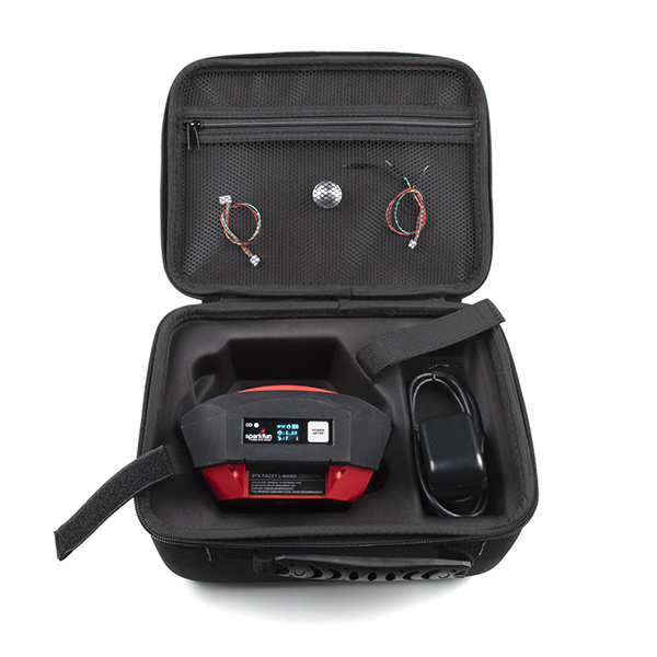
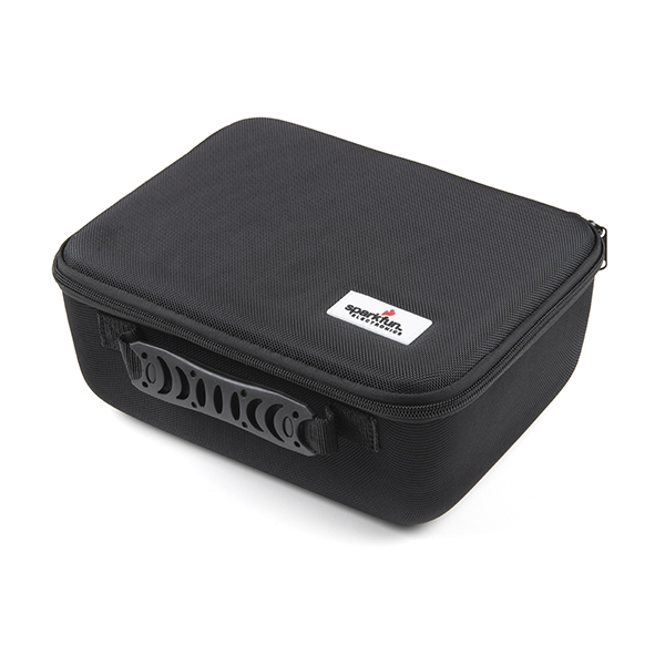
The SparkFun RTK Facet L-Band kit includes everything you need: the enclosed device, correction subscription for 12 months, thread adapter, charger, data cables, and carrying case. It does NOT include a surveying pole. These items will need to be purchased separately.
Please Note: PointPerfect L-Band correction service for the SparkFun Facet L-Band is currently only available in the USA's 48 contiguous states and the European Union shown in the coverage map below. See the interactive coverage map. If PointPerfect is not available in your area, RTK Facet L-Band is still capable of RTK precision but a local correction source will be needed.

Important: The SparkFun RTK Facet L-Band is not designed for permanent outdoor mounting. Please use the RTK mosaic-X5 or the RTK Reference Station that is located inside or protected from the elements. Or, for a DIY solution, the ESP32 attached to our ZED-F9P breakout is a great way to go. See our How to Build a DIY GNSS Reference Station tutorial for more information.
Important: The SparkFun RTK Facet L-Band is not designed for permanent outdoor mounting. Please use the RTK mosaic-X5 or the RTK Reference Station that is located inside or protected from the elements. Or, for a DIY solution, the ESP32 attached to our ZED-F9P breakout is a great way to go. See our How to Build a DIY GNSS Reference Station tutorial for more information.
Supported GIS Data Collector Software:
- SWMaps (Android and iOS)
- Field Genius
- SurvPC
- Survey Master
- Vespucci
- QGIS
- QField
- Any GIS software that uses Bluetooth SPP or BLE
Overall Device
- Enclosed Facet Design IP53 - Protected from limited dust ingress and water spray
- Internal Antenna: L1/L2/L-Band with ≥5dBi gain
- Internal Battery: LiPo 6Ah with fast 1 amp charging
- Radio Port: 3.3V TTL Serial (57600bps RTCM TX/RX)
- Data Port: 3.3V TTL Serial (115200bps NMEA)
- Qwiic Port: Supports I2C based add-on devices
- microSD: Compatible up to 32GB
- Embedded OLED Display for positional accuracy, available satellites, data logging, etc.
- Single push button control
- Weight: 598g (1.3 lbs)
- Dimensions: 136mm x 146mm x 80mm (5.35in x 5.74in x 3.14in)
- Works with common GIS software including: SW Maps, SurvPC, Field Genius, et al.
- Open Source Hardware Certified Project
- Manufactured in Boulder, CO USA
GNSS Receiver: ZED-F9P
- Concurrent reception of GPS, GLONASS, Galileo, and BeiDou
- Receives both L1C/A and L2C bands
- 184-channel u-blox F9 engine
- Current: 68mA - 130mA (varies with constellations and tracking state)
- Time to First Fix: 25s (cold), 2s (hot)
- Max Navigation Rate:
- PVT (basic location over UBX binary protocol) - 25Hz
- RTK - 20Hz
- Raw - 25Hz
- Horizontal Position Accuracy:
- 2.5m without RTK
- 0.010m with RTK
- Max Altitude: 50km (31 miles)
- Max Velocity: 500m/s (1118mph)
Satellite Data Receiver: NEO-D9S
- L-Band data receiver compliance: SESTB28A
- Frequency range: 1525 to 1559MHz
- Sensitivity: 133dBm
- Current: 35 - 130mA (varies during acquisition and tracking state)
- Time to First Frame: <10s
- Receives PMP messages from Inmarsat Geosynchronous Satellites
Bluetooth® Transceiver: ESP32 WROOM
- Xtensa® dual-core 32-bit LX6 microprocessor
- Up to 240MHz clock frequency
- 16MB of flash storage
- 520kB internal SRAM
- Integrated 802.11 BGN WiFi transceiver
- Integrated dual-mode Bluetooth® (classic and BLE)
- Hardware accelerated encryption (AES, SHA2, ECC, RSA-4096)
- 2.5 µA deep sleep current
SparkFun RTK Facet L-Band Product Help and Resources
Core Skill: DIY
Whether it's for assembling a kit, hacking an enclosure, or creating your own parts; the DIY skill is all about knowing how to use tools and the techniques associated with them.
Skill Level: Noob - Basic assembly is required. You may need to provide your own basic tools like a screwdriver, hammer or scissors. Power tools or custom parts are not required. Instructions will be included and easy to follow. Sewing may be required, but only with included patterns.
See all skill levels
Core Skill: Programming
If a board needs code or communicates somehow, you're going to need to know how to program or interface with it. The programming skill is all about communication and code.
Skill Level: Competent - The toolchain for programming is a bit more complex and will examples may not be explicitly provided for you. You will be required to have a fundamental knowledge of programming and be required to provide your own code. You may need to modify existing libraries or code to work with your specific hardware. Sensor and hardware interfaces will be SPI or I2C.
See all skill levels
Core Skill: Electrical Prototyping
If it requires power, you need to know how much, what all the pins do, and how to hook it up. You may need to reference datasheets, schematics, and know the ins and outs of electronics.
Skill Level: Rookie - You may be required to know a bit more about the component, such as orientation, or how to hook it up, in addition to power requirements. You will need to understand polarized components.
See all skill levels
Comments
Looking for answers to technical questions?
We welcome your comments and suggestions below. However, if you are looking for solutions to technical questions please see our Technical Assistance page.
Customer Reviews
3.7 out of 5
Based on 9 ratings:
3 of 3 found this helpful:
Very Nice Device!
It's veryaccurate, compact and easy to use. When will the IOS app become available? We can't use it to it's fullest potential until IOS is available!
2 of 2 found this helpful:
Great device.
Accuracy, price and support excellent… it reduce a lot work.
4 of 4 found this helpful:
Great survey instrument
This is meeting all the expectations that I had when I decided to purchase it. It gets accurate readings with in the 14 mm range. I don't have to set up base station to get those readings.
3 of 3 found this helpful:
Value for money!
This product is wonderful at its price point. I tried the L-Band Correction and I marvel at the accuracy it can deliver without any base unit. No other GNSS receiver on the market that I know of delivers RTK correction via radio, internet, and L-band from a satellite and remains this affordable. Nonetheless, I hope the next gen of this product has an in-built sim card (LTE) as well as an in-built radio. What will even be more orgasmic is having this l-band RTK on survey drones and please add IOS support. I really hope the point-perfect coverage hits Africa.
5 of 6 found this helpful:
Fantastic performance
Everything worked as advertised! Had it set up in a few minutes. Just had to get it connected to a wifi network to download the keys. Once the keys was downloaded, it took about 1-2 minutes and the accuracy was down to an avg. ~14-16mm horizontal accuracy. The unit also supports several ways to extract the 4Hz positioning data using different protocols. Wonderful product!
0 of 5 found this helpful:
Completely off the mark
The facet L band GNSS has been nothing more than an extremely expensive toy to this point. And most cases it is less accurate than my iPhone. I have a completely clear view of the sky and can only achieveWith any regularity 300 to 500 mm accuracy. The learning curve is rather steep, out of the box this unit is nowhere near ready go. It took two or three weeks researching through the forum to find a possible solution and even begin setting this up. Now I’m outside the return window and likely stuck with this lovely paperweight.
Sorry to hear you are having trouble with your unit. It looks like we sent you a return label on the 16th of January. Your ticket is still open. If you wish to still return the unit, please respond to the support ticket we already have open for you.
0 of 4 found this helpful:
Preliminary review
Out of the box it's not doing what the manual and the youtube videos say. There's no instruction on how to connect to WiFi to get the keys and it's not connecting to WiFi to get the keys. The best I am seeing is 1.5ft horiz and vert accuracy. Not cool. Any suggestions on how to access the RTK correction keys would be greatly appreciated. Also, no 'car' icon when I select Rover mode. I have version 2.2 of the firmware and one menu item is 'mark' another is 'bubble' and neither appears to be documented anywhere.
Hi - 1.5ft out of the box is right on the money. To enter your home WiFi credentials please see the Product Manual, section PointPerfect Menu. Once your credentials are entered, you'll obtain keys and L-Band corrections in no time.
0 of 1 found this helpful:
Engineer's Review: Not Accurate Enough for Professional Use
Executive Summary: I bought the Facet L-Band GNSS receiver to see if it could be used on my projects, but it wasn't accurate enough vertically and the L-Band feature was useless. After three weeks, the device has stopped working. I can't recommend it to people who are looking for a survey grade GNSS receiver.
I want to preface this review by stating that I'm a registered professional engineer in the state of Virginia. Per Virginia code, P.E.s can practice land surveying if it is incidental to an engineering project. I work in land development and am looking into equipment options for future jobs and thought to give this a try and see what it can do. I've had the product for approximately three weeks now and here are my thoughts.
Current Status of Device: It has stopped functioning. It's not powering on even after charging. As of right now, I have a $1,500 brick that I'm hoping to get a return on. I'll change my review to three stars if I can get a refund, but I'll update on that.
Sparkfun Customer Service: The customer service is very lacking. I accidentally placed an order on the l-band facet ($1,500) versus the regular facet ($800). I immediately reached out via the customer service email, there is no customer service phoneline, and didn't get a response back until two days later after it had been charged. I thought, no worries I'll see what the l-band features do and decided to keep it.
First Reception: This facet is essentially a plastic housing around the L1/L2 antenna, and computer boards. I'm not an electronics guy, I just know that there's a slot for usb-c, microSD, and the power button. The black cover is a rubbery cover that protects the device from dust and dirt, but is not seal tight. It takes about 10 minutes for someone to connect it to the wifi and get the keys for the l-band. I noticed that unlike other gnss receivers I've used, this was not waterproof so user beware.
Horizontal Accuracy: I decided to go out and find a survey control monument in my City. I took the facet, a standard survey pole with a bubble (AdirPro from amazon), and my phone with SW-Maps. I used pointone RTCM service on the 14 day trial. I powered it on and walked to where I knew the monument was. Surprisingly, it was extremely accurate (At least in the horizontal. I did some other measurements, recorded the data in SW-Maps, and went back to the office for some post-processing. I found that the horizontal was accurately described. With rapid surveying for topo, I was averaging 20mm accuracy.
RTK Fixes: I did notice that this receiver drops fixes a lot more than other receivers I've used. That was while using both the RTCM corrections and the L-band corrections.
Instrument Height: I couldn't find anywhere in the documentation what the instrument height should be set at. They reference that the "L1 is here, L2 is there" but that doesn't tell me what I need to use to determine my instrument height. Other manufacturers say "Add X.XX' to your rod height" but there isn't anything here.
Vertical Accuracy: This is where we go down the slippery slope. So, I decided another test to see if this could be used on my jobs is to confirm the vertical accuracy. Anyone working in my field knows that vertical accuracy is just as important as horizontal. So I went to two vertical control benchmarks in my City with established vertical elevations. These weren't local benchmarks but ones established by the City itself. In NAVD88, the elevations of the two controls were 12.66' and 13.93' respectively. A little math, that's a vertical delta of 1.27'. With that I went to the first one, set a control observation (30 observations with an RTK fix). I got an ellipsoidal height of -105.429 ft (converted from meters). I then found the GEOID18 height at the point found, which was -119.944 (NOAA GEOID18 based on lat/lon of the observed point). From the previous bullet, I couldn't find an exact height of the HI so I best determined it was 6.70' based on my pole at the mid point of the L1/L2 locations. I did the ortho calculation: Eh - Geoidh - Hi (https://www.ngs.noaa.gov/PUBS_LIB/gislis96.html) = -105.029 - - 119.944 - 6.7 = 8.215....Okay, maybe I messed something up? Per FieldGenius Android, the vertical deviation was 0.007' with 30 observations... Tell you what, let me check the delta from the ellips height of the two points and compare. luckily the established benchmarks are only 1000 feet away. Ellips1 = -105.029' and Ellips2 = -103.477'. Delta of the Ellips is 1.55' with a std of the second is 0.009'...So, delta of ellips (because they're so close, ellips delta approx= ortho delta) is 1.55', with deviations is 0.007'-0.009', versus 1.27' from the benchmarks. A difference of 0.28'. So there's a second check that I can't verify. I went ahead and checked some more benchmarks and I can't verify any of the vertical info. I can get accurate vertical control with other receivers, but I cannot with this Facet L-Band. For my work, I can't be that far off with vertical error.
L-Band Feature: The L-Band is advertised essentially as being an option if you cannot get an RTK fix with a base station. All you need to do is connect to the wifi every 56 days so that the device can get encryption keys to use the L-Band service. Another note is that it's still a subscription service, it's just that users get the first year for free. So it's use case is for ares without celluar data or that can't use a base & rover setup. I initially used this feature but quickly found that the RTCM corrections via the NTRIP network I was on received a more accurate fix. L-band was averaging 60mm like it is advertised versus the 20mm from Additionally it was consistently faster at getting a fix. With that said, I personally found that the L-Band feature was pretty pointless for me. So, should you try the L-Band over the regular facet? You have to ask yourself the following questions: Are you going to have cellular service in the area? Yes, use a NTRIP. If no, can you use a temp base over an established point? If yes, use the base. If no, then look into the L-Band features.
Base and Rover: I haven't used a temp base and rover setup with this, but in my experience I would use that in situations where I can't get celluar service.
"Surveying" Capabilities: I think under the right circumstances, this can be used to determine horizontal improvements with accuracy. With a lot of work, more than what you need with other equipment, you could even close out boundaries. But I can't recommend this for anyone needing extreme vertical accuracy like what professionals need for land surveying or engineering projects.
PPK Solutions: The description claims that there is a process for taking the PPP and converting it to data to perform a PPK solutions. However, it's convoluted and not straight forward. In base mode, the receiver records RAWX data, which is nice, but typical format for PPK solutions are RINEX. Let's say for example, you want to perform a static survey over a point to establish coordinates. In theory, you take the facet, set it up over a point perfectly ( I recommend tripod and tribrach ). You take a microsd, pop it in the facet, and turn it on base mode. Let it sit for at least 2 hours over the point and then take the data and process it through a PPK service like NOAA OPUS. However, you have to do an extra step and convert the RAWX to RINEX.
App Options: Sparkfun's preferred app is SWMaps, which is good for simple applications and GIS, but it is not a good surveying app. It doesn't have stakeout or offset options, which I think is essential for surveying. My recommendation is FieldGenius (or trying to free 30day trial.) That app is more tailored for accurate surveying.
Exactly what I was looking for
I wanted accurate property boundaries in order to build some non- permanent fences and clear trails. A professional survey for my 8 acres would have cost more than double what the SparkFun RTK Facet L-Band cost. It was easy to get the device up and running and paired with my iPhone. Works great when there’s an unobstructed view of the sky; takes longer in my woods (currently winter so no leaves); we’ll see how it works wince the canopies fill in. Regardless, the product has exceeded my expectations.