
HAB - Lessons Learned
A story of the electronics and logistics of launching a high altitude balloon.
High Altitude Balloon Page:
- HAB Intro
- Sensor system, Flight Computer and Radio System
- Still and Video cameras
- The Balloon, Enclosure, Helium, and Cut-Down
- Enclosure and Heater System
- Weights, Measures, and Costs
- Lessons Learned
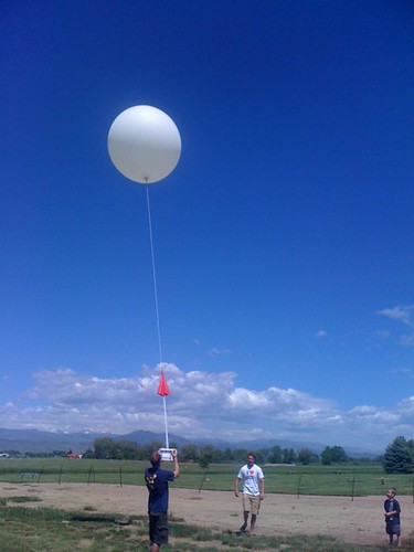
Lessons Learned
Document your failures, right? Here's some of the gotchas and ideas that, if you decide to launch your own balloon, may help ease the pain.
Have a full tank of gas. You will be driving a tremendous amount (nearly 300 miles in one day) depending on conditions. You really don't want to be 4 miles into a corn field, 30 miles outside of no where just to have your gas light turn on. It's bad.

Bring a friend. Rob and Felicia were nice enough to join me on this wild adventure. It was really great to have other folks there to help. A radio operator, a driver, and a navigator are usually needed. If you've got a really good software/tracking setup, it can usually supplant one of these positions. The way it worked for us, Felicia would read off the various bits of incoming data. One of the following was transmitted by the box every second: Lat, Long, Alt, Pressure, or Box temperature. She was pretty good at throwing out garbled messages (humans make great data filters) and relaying the received coordinates to Rob who would then find that point on the map (took some time). Rob would then have to decide a course and tell me where to drive. It was quite cumbersome, but it worked. It worked until the balloon decided to go south east and the highway we were on turned directly north.

Have lunch in the car. Balloons don't take a break. If you're in the chase, you don't want to stop. And around 2PM, you'll be hungry as you go tromping through the weeds looking for your precious balloon. Have lots of water. It can be a bit desolate out there.
Bring a paper map. Bring a good one with GPS grids. We knew that cell phone reception (ie, GoogleMaps) would probably not work, so we brought along the Colorado Atlas and Gazetteer atlas with GPS grids. One of the most frustrating and scary things where the seams on the map. The balloon insisted on flying a path just slightly in between the bottom of one page, and the side of another. This caused some major problems, flipping back and forth, checking scales and trying to convert GPS coordinates on the fly. I've heard some people bring a GPS car nav system. While we did make some mistakes choosing which routes to take, I'm unsure how helpful or fast it would be to type in lat/long into a nav system especially with the spotty records of roads this far out.
Bring an inverter. There will be lots of laptops and electronics needing juice. You'll need a DC to AC inverter to charge it all from the car's cigarette adapter. If you're paranoid, bring two.

Bring a GPS logger. Rob was smart enough to kick on his Android and start logging our GPS coordinates. You can check out the overall path that we took (including the spot where I got pulled over for speeding). We drove all over the place trying to estimate where the balloon might be coming down and/or have landed. Be patient, it takes a second or two to load into Google Maps.
Be able to tether your cell phone. What we found surprised us - there is actually cell reception in some far off places. During the whole GPS mapping/tracking debacle, we found ourselves in the middle of a wheat field. Rob pulled out his phone and discovered we did have limited data connection. It could have been REALLY helpful had we had access to google maps the entire time! Next launch, I will probably use google maps via cellular first, then local mapping software on my computer next, and then the paper map as a last resort.
Find a software mapping solution. Ideally, the computer would receive the periodic updates from the balloon. I intend to write a VB or python script to bring in these bits of data, check them for errors (a simple checksum or known data width would suffice), and then reform the information into NMEA sentences that Microsoft Streets and Trips can understand. I've looked into all sorts of offline mapping programs (load up google maps onto your laptop!). Unfortunately all the programs I've found are fairly limited in their abilities, interface, or API for inputting a given long/lat coordinate. I don't need driving directions, I just need you to put an arrow right where this coordinate is! If someone has a better suggestion, we are all ears.
Test your radio. This goes without saying, but this balloon was lost because 'hoping it would work out' overcame common sense. But sometimes this is the only way to truly learn. For the next flight, we will be using a different radio system. Possibly audio based with decent output power, with more sensitive receiver, and no digital protocol to delay possibly good data (just raw 1s and 0s). I have considered using a cellular backup and based on our field tests, there is a good likelihood we would have cellular reception a few hundred feet above the ground to transmit a text message. Take a day and drive into the country - see how far you can get reception with your radio on the ground. Blind yourself, spin around in a circle a bit, and try to locate the transmitter by any means but visually. On the day of the launch, you will have no idea where the balloon is - see if you can locate it by antenna direction.
A better name tag. I did put my name and phone number on the outside of the payload, but regrettably, it was not laminated so I assume it is destroyed by now. For future launches, I will include a hardily protected name/contact/information sheet on the payload. Possibly a PCB that has the info etched in copper - that should last for awhile, right? Thanks to DaveP on the SparkFun comments, I see that some payloads have taken as long as 815 days to be found! So you're saying there's a chance...

Predict your flight. This suggestion comes from StillDavid. There is a surprisingly accurate balloon flight predictor that will help you get an idea of how far the balloon may travel day of, and where it might be headed. I ran this the night before, and then the following morning before the flight. Finally, when the balloon had not been heard from for an hour, we pulled out Rob's laptop (in the middle of the wheat field) and re-run the prediction. We got variances each time but it gave us some direction which was very helpful, if not fruitful.
Resources
There are tons of good resources out there on google. Here are a couple that we read:
It's always good to read the FAA regulations. Don't take my word for anything. This link directly to the FAA site may work. If not, you can check some of the other sites that have posted and interpreted the regulations for us mere mortals.
Flight prediction site - already discussed but it's important enough to list it twice. If you want to run a prediction, you can use our numbers. We launched from 40.234657,-105.1117. The altitude at that GPS coordinate is about 1600m. I leave all the other settings alone (Ascent rate, Burst altitude, etc).

Edge of Space Sciences - they seem to be the go-to guys for university programs. According to the WORPK records page, EOSS has had 145 total missions! They know exactly what they are doing and how to get it back down to the ground. Very impressive work and they even keep their site updated! There was a successful launch/recovery on July 10th, 2010.
Parallax has a decent tutorial written by Dave Harper. (Did you launch in front of your house?!) I do love that he put 'REWARD' in big letters on the outside of his payload. Good idea! There is also a rather large book called Near Space written by Paul Verhage. I haven't read through it all, but it's freely available on their website. Thanks Paul!
VPizza is a good site, but running Linux? Really?
California Near Space project. Decent photos.
High Altitude Balloon Page:
- HAB Intro
- Sensor system, Flight Computer and Radio System
- Still and Video cameras
- The Balloon, Enclosure, Helium, and Cut-Down
- Enclosure and Heater System
- Weights, Measures, and Costs
-
So that's pretty much it
The balloon is still out there. We'll let you know if we hear from someone. Thanks for reading this enormous tutorial! If you launch your own balloon, let us know! We'd love to hear about your experiences.
-Nathan
BTW, the flight predictor site has moved to http://predict.habhub.org/
How about using a parasail and adding a compass and four small motors with takeup spools. Control the parasail so the package comes back to it landing site instead of chasing it.
A fellow senior design team at my U tried exactly that; it's harder than it looks. But many people have attempted return-to-launch-site parafoils, gliders, etc. occasionally with great success.
How is the wind at 30 km? What about add some propulsion for after cut-down? It could get much higher, couldn't it?
Thanks,
Just found this guide, glad to know the predictor is proving useful to people. One tip, it is quite sensitive to the ascent rate and burst altitude parameters. We find it to be a lot more accurate when we run it with an estimate of the true ascent rate and burst altitude.<br />
<br />
There are some tools here which help to calculate these parameters:<br />
http://ukhas.org.uk/guides:balloon_data<br />
<br />
One of which is our online calculator (based on the 'burst1a' spreadsheet by Steve Randall):<br />
http://www.srcf.ucam.org/~cuspaceflight/calc/<br />
<br />
However nothing beats making an estimate from the telemetry once the balloon is in the air. We usually re-run shortly after launch with an updated ascent rate and then after burst with an updated burst altitude.<br />
<br />
This can be remarkably accurate, we have seen the payload land from the predicted spot before and usually it gets you close enough to pick up the radio on the ground.<br />
<br />
Fergus (CU Spaceflight)
For tracking and recovery, it might we worth looking into the Spot Satellite Messenger at http://www.findmespot.com/en/. Not certain how it would cope with the HAB conditions,but it has the capability to provide tracking info via satelitte communications. <br />
<br />
From the website, "...SPOT acquires and sends your GPS coordinates to your SPOT account automatically every 10 minutes for 24 hours or until canceled...Creating a SPOT Shared Page allows you to share your GPS route with your friends and family easily in near real time on the web through a personal link. You can make your Shared Page private or public. Your choice! Just share that url with your friends and family and they can easily track your adventures. You can also link your SPOT Messenger to SPOT Adventures, a social portal, where you can set up a profile and blog with others sharing their SPOT adventures."<br />
Outstanding project and thank you for bringing this to us. Have an idea, not sure a good one but I'll throw it out there for folks to look at. Slightly larger parachute and a single servo to control the spilling of air, not really steering but could bring it closer. Use the Ardupilot with return home feature turned on. Maybe, just maybe a square parachute for better glide and control but then you would want to delay opening so return wouldn't take 5 hours or so, or maybe a bit undersized for the payload so it will descend a little faster. That would add a few ounces but maybe worth it? Well, it's an idea.
This is a great thought, and I know of several groups around the world working on high-altitude gliders. The physics of falling is quite different at different altitudes, and poses some great challenges.
One thing is to read up on your local regulations if you try this. In the US, be sure to read through the FAR and Unmanned Aerial Systems Regulations before attempting any autonomous flights. I've heard some say that any autonomous flight that exceeds 500ft in altitude is considered weaponized by the FAA, so watch out! Don't want the black vans to show up.
Some friends and myself have been having HAB launches for a number of years (http://bear.sbszoo.com/) and each flight is a great adventure and more fun then the last. Most importent is to leave nothing to chance (as there's no way to fix a mistake once a balloon is released) and to run predictions before launching to know where the balloon will go and if one should perhapes launch a different day to save having to drive further then one wants or perhapes landing in a hard to reach area or where large bodies of water are present. As for tracking payloads, amateur radio APRS makes locating payloads the easiest and the RTrak-HAB tracker others mentioned is an excellent ready to use tracker for those not wanting to build something from scratch. Thanks Nathan for an excellent tutorial. I get numerous enquires from others wanting info on how to launch their own payloads and I now have a single place to direct them to that includes links to all the other main sites with additional information.
This project was awesome to read about, thanks for sharing it! It's inspired me to try it out as a summer project with my fianc?.
What radio unit are you considering for your next launch?
Check out Parallax's Near Space Documentation:
http://www.parallax.com/Resources/ApplicationsContests/Science/NearSpace/tabid/567/Default.aspx
Updated URL: http://classic.parallax.com/tabid/567/Default.aspx
Seems like you could probably build a program that spit out the GPS coordinates into Google earth. I believe GE will also take in data from a GPS system so you could see just how far you are from the box at any given moment.
Some other idea's, streamers. It may be easier to spot a brightly colored streamer floating in the breeze than a box that has splashed down in a puddle of mud. A brightly colored parachute, box, and rigging accomplish the same.
Waterproofing. doesn't have to be air tight but a flooded ditch is just as capable of ruining 800 in parts as a 100,000ft fall.
Binoculars. If you can relate a direction between you and the box binoculars may let you get a glimpse of the box coming down or any other markers on the box in a field without much trapsing around.
No idea how practical any of these are but they are my gut insticts on the matter. Cool project in any event.
Would it be possible to find a plane or helicopter that you could rent with a pilot and fly over the areas that you suspect the balloon could be? Did you paint it neon green or orange for recovery? I would think with a $800 payload it would be worth looking for it from the air :)
You might want to look into using data from OpenStreetMap.org in an "offline" manner. Because it's community collected you can get all the vector data for an area.
I've used MapDroyd for an Android phone but there are other solutions as well: http://wiki.openstreetmap.org/wiki/Offline_Openstreetmap
Sorry to double post, I thought I'd add a couple of lessons learned from a few dozen flights:
- Mechanical Connectors (rather than soldered joints) are the root of all evil - minimise the number of mechanical connections. A huge number of the issues we've experienced can be traced to connections.
Where you do have connections, make them decent locking connections (more so than the standard 0.1" polarized molex), solder the spades (not just crimp), add some heat-shrink and stress relief. Some of these payloads hit the ground pretty hard (say the balloon remains tangle with the 'chute), and it's so easy for a battery to be shaken loose or a connector to pop off. Spring terminals can be easier to work with than screw terminals, especially once you factor in the thermal contraction of screw terminals at altitude.
Basically, if you're not happy about throwing your payload down a flight of stairs, you should probably reconsider launching it!
- Cable-ties (zip-ties) become brittle at -60 degrees celcius. Don't use them for anything load-bearing. (You can guess we learned this one the hard way)
- Make sure the payload is fully on and working before you start inflating the balloon - if you inflate the balloon before initialising the payload, murphy will ensure it refuses to get a gps lock.
- Always have a spare roll of duct tape.
I would suggest 2 radios for backup. I use the xTend radio as a data radio but have a second radio that is an FRS (Family Radio Service) that has a VOX setting. I use your MP3 trigger to "say" the lat, long, and Alt every 2 minutes. Just have the 10 digits and key words as individual files. The voice makes it easy for other people to follow the action without a lot of equipment.
And forget the cell phone. It is against FCC (not FAA) rules to use one above the ground. Not to mention they don't work very well.
Would you be able to a have cell mod that you could text for the balloons coordinates?
Can I also plug the CU Spaceflight hourly predictor?
http://www.cuspaceflight.co.uk/hourly-predictions
It gives you the locus of landing spots if you were to launch each hour for the next 5 days - it's basically a 'week at a glance' view to help you see when the winds might be on your side. Being so close to the North Sea, we find it very useful to see what days could give us a dry landing.
Ed
CU Spaceflight