- Home
- Product Categories
- GPS Boards
- SparkFun RTK Express


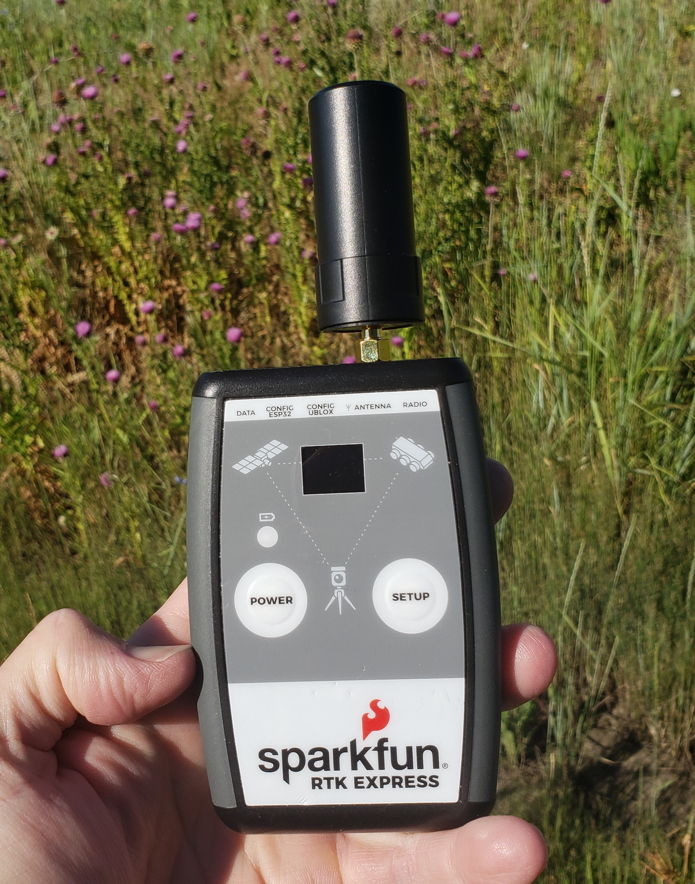
SparkFun RTK Express
The SparkFun RTK Express is an easy to use GNSS receiver for centimeter-level positioning. Perfect for surveying, logging, and all types of post processing, this preprogrammed device can also be used for autonomous driving, navigation, asset tracking and any other application where there is a clear view of the sky. The RTK Express can also be used as a base station. With the press of a button, two RTK Expresses can be used to create an RTK system capable of 14mm horizontal positional accuracy. The built-in Bluetooth® connection via an ESP32 WROOM enables the user to use the RTK Express with their choice of GIS application on a phone or tablet. The built in battery allows for over five hours of field use and is compatible with common USB battery banks.
The RTK Express works with common GIS software for Android and iOS including SW Maps (Android / iOS), ArcGIS Survey123, Field Genius, SurvPC, Survey Master, Vespucci, QGIS, QField (Android / iOS), and any GIS software that supports NMEA over Bluetooth or TCP.
We took all the lessons from the RTK Surveyor and built the RTK Express. The RTK Express is built upon the same ZED-F9P u-blox receiver as the original RTK Surveyor so you can expect the same incredible performance and rich feature set. The embedded display allows for immediate feedback of horizontal positional accuracy, satellites in view, logging status, survey-in status, battery level, Bluetooth® MAC, etc. The rocker switches found on the original have been replaced by keypad buttons. We increased the battery to 1300mAh for a longer run time. The internal switches have been replaced by a digital Mux allowing for some really exciting applications including event triangulation. More ESD protection was added to protect the RF path, and we even threw in an accelerometer for digital leveling in the field.
This device can be used in four modes:
- GNSS Positioning (~30cm accuracy)
- GNSS Positioning with RTK (1.4cm accuracy)
- GNSS Base Station
- GNSS Base Station NTRIP Server
In Position mode the device receives L1/L2 signals from a user-provided antenna and the high-grade GNSS receiver provides lat/long and altitude with accuracies around 300mm.
In Positioning with RTK mode the device receives L1/L2 signals from the antenna and correction data from a base station. The correction data can be obtained from a cellular link to online correction sources or over a radio link to a second RTK Surveyor/Express setup as a base station.
In Base Station mode the device is mounted to a temporary position (like a tripod) and begins transmitting correction data over a radio or Internet connection. A base is often used in conjunction with a second unit set to 'Positioning with RTK' to obtain the 14mm relative accuracy. The RTK Surveyor and RTK Express are interchangeable as a Base Station; an RTK Surveyor can be a base for an RTK Express and vice versa.
In Base Station NTRIP Server mode an antenna is mounted to a semi or permanently fixed position (like a roof), a cable is run indoors, and the device connects over WiFi to transmit the correction data to a NTRIP caster so that any rover can access the correction data over a cellular or Internet connection. This type of base is a very easy way to set up a very precise absolute correction source.
Two cables are provided with the RTK Express allowing a user to plug in our easy to use Serial Telemetry Radios or their own radio link. If a local correction source is within 10km, a user can also use their phone to provide correction data over the Bluetooth® link (no external radio needed!).
Note: The SparkFun RTK Express is just the enclosed device and does NOT include an antenna, serial telemetry radio, or associated mounting pieces. These items will need to be purchased separately from the Hookup Accessories below.
Important: The SparkFun RTK Express is not designed for permanent outdoor mounting. Please mount the L1/L2 antenna (which we've had outside constantly for over three years in Colorado UV) outside with a SMA cable running to the RTK Express that is located inside or protected from the elements. See Creating a Permanent Base for more information.
Supported GIS Data Collector Software:
- SWMaps (Android and iOS)
- Field Genius
- SurvPC
- Survey Master
- Vespucci
- QGIS
- QField
- Any GIS software that uses Bluetooth SPP or BLE
GNSS Receiver: ZED-F9P
- Concurrent reception of GPS, GLONASS, Galileo and BeiDou
- Receives both L1C/A and L2C bands
- Current: 68mA - 130mA (varies with constellations and tracking state)
- Time to First Fix: 25s (cold), 2s (hot)
- Max Navigation Rate:
- PVT (basic location over UBX binary protocol) - 25Hz
- RTK - 20Hz
- Raw - 25Hz
- Horizontal Position Accuracy:
- 2.5m without RTK
- 0.010m with RTK
- Max Altitude: 50km (31 miles)
- Max Velocity: 500m/s (1118mph)
Bluetooth® Transceiver: ESP32 WROOM
- Xtensa® dual-core 32-bit LX6 microprocessor
- Up to 240MHz clock frequency
- 4MB of flash storage
- 520kB internal SRAM
- Integrated 802.11 BGN WiFi transceiver
- Integrated dual-mode Bluetooth® (classic and BLE)
- Hardware accelerated encryption (AES, SHA2, ECC, RSA-4096)
- 2.5 µA deep sleep current
Overall Device
- Internal Battery: LiPo 1300mAh with 500mA charging
- Radio Port: 3.3V TTL Serial (57600bps RTCM TX/RX)
- Data Port: 3.3V TTL Serial (115200bps NMEA)
- Embedded OLED Display for available satellites, data logging, and more.
- Push button controls
- Weight: 162g (entire device including battery)
- Dimensions: 132mm x 101mm x 32mm (5.2in x 3.9in x 1.2in)
- 1x Qwiic Connector
- Works with common GIS software including: SW Maps, SurvPC, Field Genius, et al.
Changes: This version (which replaces SPX-18019) uses a reinforced edge mount SMA connector for better resiliency when a fixed 'stub' antenna is used.
- Hookup Guide
- RTK Product Manual
- Schematic
- Firmware Repo
- Hardware Repo
- Certified OSHW: US002050

SparkFun RTK Express Product Help and Resources
How to Build a DIY GNSS Reference Station
October 15, 2020
Learn how to affix a GNSS antenna, use PPP to get its ECEF coordinates and then broadcast your own RTCM data over the internet and cellular using NTRIP to increase rover reception to 10km!
Setting up a Rover Base RTK System
October 14, 2020
Getting GNSS RTCM correction data from a base to a rover is easy with a serial telemetry radio! We'll show you how to get your high precision RTK GNSS system setup and running.
SparkFun RTK Express Hookup Guide
June 21, 2021
Learn how to use the enclosed RTK Express product to achieve millimeter level geospatial coordinates.
How to Upgrade Firmware of a u-blox GNSS Receiver
March 26, 2021
A few steps and you'll upgrade to the latest features on a u-blox GNSS receiver.
Core Skill: Programming
If a board needs code or communicates somehow, you're going to need to know how to program or interface with it. The programming skill is all about communication and code.
Skill Level: Competent - The toolchain for programming is a bit more complex and will examples may not be explicitly provided for you. You will be required to have a fundamental knowledge of programming and be required to provide your own code. You may need to modify existing libraries or code to work with your specific hardware. Sensor and hardware interfaces will be SPI or I2C.
See all skill levels
Core Skill: Electrical Prototyping
If it requires power, you need to know how much, what all the pins do, and how to hook it up. You may need to reference datasheets, schematics, and know the ins and outs of electronics.
Skill Level: Rookie - You may be required to know a bit more about the component, such as orientation, or how to hook it up, in addition to power requirements. You will need to understand polarized components.
See all skill levels
Comments
Looking for answers to technical questions?
We welcome your comments and suggestions below. However, if you are looking for solutions to technical questions please see our Technical Assistance page.
Customer Reviews
4 out of 5
Based on 1 ratings:
Nice tool
Initial out of box was easy. Am still attempting to link with my FTM400. The 900 MHz units shown in the set up Youtube are no longer available so I'm going with the higher power licensed unit and avoid extra stations. To do this as required I still need a laptop sized program that will convert the output to cadestral
I have a pair of this little titans! Are amaizing for surveying. But I can't use it for too long... Can I charge the unit with a powerbank while I'm using it? Which usbC port should I connect it to to charge while using it? Thanks for all the effort you put on your products!
Thank you for the kind words! Happy to hear it is working well.
Yes, an external power bank works great. Plug the power bank into the CONFIG UBLOX connector for the most efficient charging.
I am very exited to have this very useful rtk tool, i am from Argentina and here there is nobody using this wonderfull equipmentent , i already have the gnss L1/L2 antena and its a very nice and good for surveying!