- Home
- Product Categories
- GPS Boards
- SparkFun RTK Torch


SparkFun RTK Torch
The SparkFun RTK Torch is your one-stop shop for high-precision geolocation and GIS needs. We compiled your wish list and got it all: tri-band reception, tilt compensation, and millimeter accuracy; all protected inside of a waterproof housing.
With just the press of a button, the RTK Torch is the fastest way to take millimeter-grade measurements. By connecting your phone to the RTK Torch over Bluetooth, your phone or tablet can receive the NMEA output and work with most GIS software. This is exactly how professional-grade surveying devices have been operating for the past decade - we just made it faster, more precise, and a lot more economical.
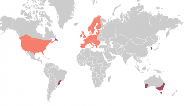
The RTK Torch includes a feature we call Zero-Touch RTK. Register the device, give the device the WiFi credentials for a hot spot or other WiFi network, and it will begin getting corrections without any further setup. No NTRIP credentials required! These corrections are obtained over WiFi from u-blox PointPerfect and are available in the US, EU, and various parts of Australia, Canada, Brazil, and Korea (see the coverage map). The RTK Torch includes a one month free subscription to PointPerfect. Additional subscriptions can be purchased if desired. If PointPerfect coverage is not available in your area, corrections from a local base station or service can be provided to the device over NTRIP (delivered via Bluetooth or WiFi).
We've upgraded the housing to a fully IP67 rated enclosure, so it’s waterproof when submerged up to 1 meter for up to 30 minutes when the USB cover is closed. The RTK Torch comes in a hard sided carrying case with lots of room for a tablet, data collector, or other device.
Under the hood of the SparkFun RTK Torch is an ESP32, a UM980 L1/L2/L5 high precision GNSS receiver from Unicore, and an IM-19 for tilt compensation. The addition of the L5 reception makes this portable GNSS device ideal for densely canopied areas where normal L1/L2 reception may have problems.
This device can be used in a variety of modes but these are six of the most common:
- GNSS Positioning (~400mm accuracy) - also known as 'Rover'
- GNSS Positioning with RTK (8mm accuracy) - using a local base station
- GNSS Positioning with PPP-RTK (14 to 60mm accuracy) - using PointPerfect corrections
- GNSS Positioning with Tilt Compensation
- GNSS Base Station
- GNSS Base Station NTRIP Server
For more information on how each of these modes work, check out the hookup guide.
The RTK Torch runs open source software meaning you can fully obtain, see, and even modify the functionality of the device. This allows for easier feature expansion, bug maintenance, and longer device longevity.
The SparkFun RTK Torch kit includes everything you need: the enclosed device, thread adapter, charger, data cables, and carrying case, along with a free one month subscription to PointPerfect for RTK corrections via Internet. It does NOT include a surveying pole. Any additional items will need to be purchased separately.
Please Note: PointPerfect IP based correction service for the SparkFun Torch is currently only available in select areas shown in the coverage map below. See the interactive coverage map. If PointPerfect is not available in your area, RTK Torch is still capable of RTK precision but a local correction source will be needed.
Important: While the SparkFun RTK Torch is fully water proof, we do not recommend it for permanent outdoor mounting. Please use the RTK mosaic-X5 or the RTK Reference Station that is located inside or protected from the elements. Or, for a DIY solution, the ESP32 attached to our ZED-F9P breakout is a great way to go. See our How to Build a DIY GNSS Reference Station tutorial for more information.
Important: While the SparkFun RTK Torch is fully water proof, we do not recommend it for permanent outdoor mounting. Please use the RTK mosaic-X5 or the RTK Reference Station that is located inside or protected from the elements. Or, for a DIY solution, the ESP32 attached to our ZED-F9P breakout is a great way to go. See our How to Build a DIY GNSS Reference Station tutorial for more information.
- 1x SparkFun RTK Torch
- 1x Hard-Shell Carrying Case
- 1x USB-C to USB-C Charging Cable
- 1x USB A and C Power Delivery (PD) Wall Adapter - 65W
- 1x Antenna Thread Adapter - 1/4in. to 5/8in.
- 1x SparkFun Sticker
Supported GIS Data Collector Software:
Android:
- Field Genius
- QField
- QGIS
- Survey Master
- SurPad
- SurvPC
- SW Maps
- Vespucci
- Any GIS software that supports NMEA over Bluetooth or TCP.
iOS:
- ArcGIS Survey123
- QField
- SW Maps
- Any GIS software that supports NMEA over TCP.
Overall Device
- Enclosed Aluminum and Plastic Design IP67 - Protected from water up to 1 meter for 30 minutes
- Internal Antenna: L1/L2/L5 with ≥2.3dBi gain
- Internal Battery: LiPo 7.2V 6.8Ah 48.96Wh with fast 10W charging
- Run time: 26+ hours on a full charge
- Single push button control
- Weight: 428g (0.94 lbs)
- Dimensions: 71 x 71 x 147mm (2.8 x 2.8 x 5.8in)
GNSS Receiver: UM980
- 1408-Channel concurrent reception of GPS, GLONASS, Galileo, BeiDou, QZSS
- GPS: L1C/A, L1C*, L2P(Y), L2C, L5
- GLONASS: L1, L2
- Galileo: E1, E5a, E5b, E6*
- Beidou: B1I, B2I, B3I, B1C, B2a, B2b*
- QZSS: L1, L2, L5
- SBAS
- Horizontal Accuracy
- Autonomous: 1.5m
- DGPS: 0.4m
- RTK: 0.8cm + 1ppm
- Vertical Accuracy
- Autonomous: 2.5m
- DGPS: 0.8m
- RTK: 1.5cm + 1ppm
- Max Altitude: 18km (11 miles)
- Max Velocity: 515m/s (1152mph)
- Bands marked with * are only supported by specific firmware.
Bluetooth® Transceiver: ESP32 WROOM
- Xtensa® dual-core 32-bit LX6 microprocessor
- Up to 240MHz clock frequency
- 16MB of flash storage
- 2MB of PSRAM
- 520kB internal SRAM
- Integrated 802.11 BGN WiFi transceiver
- Integrated dual-mode Bluetooth® (classic and BLE)
- RTK Torch Schematic
- Register PointPerfect Subscription
- RTK Everywhere Product Manual
- UM980 Datasheet
- UM980 GNSS Receiver Commands
- IM19 Tilt Sensor Datasheet
- BQ40Z50 Battery Pack Manager Datasheet
- BQ40Z50 Battery Pack Manager Technical Reference
- HUSB238 USB PD Sink Controller Datasheet
- HUSB238 USB PD Sink Controller Registers
- Building a GNSS System
- Learn More About RTK Surveyors
- GitHub Firmware Repo
SparkFun RTK Torch Product Help and Resources
Comments
Looking for answers to technical questions?
We welcome your comments and suggestions below. However, if you are looking for solutions to technical questions please see our Technical Assistance page.
Customer Reviews
4 out of 5
Based on 1 ratings:
1 of 2 found this helpful:
Works well with SW Maps
It works well with SW Maps compared to rovers like Trimble R12i that has a significantly higher price.
But with a more competent App like Surpad things go wrong with tilt enabled. Hopefully it will be addressed soon.
Works great with SW Maps but using tilt with Surpad doesn’t work. Probably a NMEA format problem.
The Torch receiver looks very interesting with some of the key features. One more question on the LoRa. In one of the videos you mention a 915 MHz LoRa RF module. Is this module also capable of transmit/receive at 868 MHz (e.g. for Europe)? by setting in software? If not, are there plans for a EU version?
The LoRa radio is specifically tuned to 902-928MHz and will not be compatible at 868MHz.
At this time we don't plan on a EU version for LoRa support.
What type of warranty for hardware or support is provided with the Torch?
A 12 month warranty is included.
Hi, can Torch use corrections from Galileo HAS? And did you test it with Esri software (Field Maps, S123, QuickCapture)? I also see UM980's performance degrades if BeiDou is not present. What is your experience?
Yes, the Torch supports Galileo HAS. Please see our Torch test results here (summary, ~80mm was achieved in under 10 minutes). We have not tested with Esri. You can see the current tested software here. We have not tested performance when BeiDou is turned off but constellation control is supported.
Does the tilt compensator work with Fieldgenius? Looks like an awesome product if it does. Similar internals to the Stonex/Hemisphere/Carlson GNSS units for a fraction of the price.
The Torch is compatible with Field Genius but we haven't yet tested the tilt sensor. We believe it will be since the RTK Torch modifies the NMEA before transmission to the GIS software (so it shouldn't know or care that tilt compensation is happening) but we all know what happens when you assume... We'll try to get it tested this follow week.
I'm setting up my new Torch. In the docs, it states "The ARP for the RTK Torch is 115mm to L1 and 118mm to L2/L5 reception." . The numbers refer to the offset from the base of the Torch
But in a video, Steven Wells states that the ARP is the base of the unit.
Which should I use? If it is the offsets, how can I enter two separate values (in SW MAPS, for instance) and how do I know which satellite band is being used (L2, L2 or L5) so I know which offset is accurate at that moment?
The Torch has an L1 antenna phase center of 115mm, and a L2/L5 phase center of 118mm. These are distances from the antenna reference point (basically the bottom of the unit). We're checking on this, but if the GIS app only has room for one ARP (or more technically 'ARP to APC'), the consensus seems to be to average the APCs: 115+118 / 2 = 116.5mm. So if you have a 1.8m long pole, you need to enter 1.8+0.1165 = 1.9165m into SW Maps. If the data entry is limited to three decimals then it's deal's choice of what to do with the 500 microns. At that point the thermal expansion of your surveying pole needs to be accounted for...