We're celebrating GIS day with deals all week on some great GPS/GNSS products, but let's take a closer look at what GIS is and how it affects your everyday life -- chances are it's more than you think!
Maps, data, analysis and apps are all integral parts to the GIS pipeline. Graphic: ESRI
What is GIS?
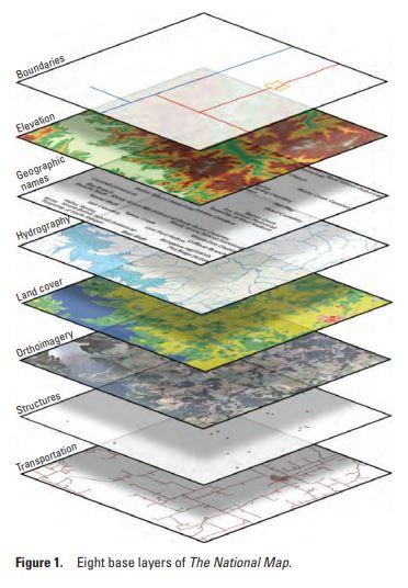
GIS stands for Geographic Information System, and it's a computer system that collects, stores, analyzes and visualizes data that is somehow related to global positioning. GIS can show may different layers of data on one map, so streets, buildings, and vegetation can be seen alongside other position-relevant data such as crop yield or elevation. These systems enable people to see how these different data categories influence each other more easily.
Graphic: US Geological Survey
What is GIS used for?
GIS has almost limitless applications, and many researchers are using it for projects that go above and beyond surveying land. On ArcGIS's website (a popular GIS) you can view a gallery of data stories its users have put together with their research and data analysis.
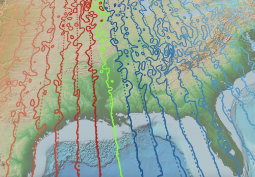
The National Center for Environmental Information (part of NOAA), created a model of the Earth's magnetic field. To create this, they used a ton of different means for data collection, compiled from data collected by magnetometers on satellites, ships, and even some aboard or towed behind aircraft. They've mapped the strength of static magnetic anomalies, and you can interact with a globe that points out where these anomalies lie and gives you background information on all of them.
Mapping of the Earth's magnetic field. Graphic: NCEI
Check out the rest of the gallery to see some more projects and play around with the interactive geographic data!
How can I use GIS?
There are many different kinds of software to choose between when you start out using GIS, and they each have certain strengths. Luckily for you (and for me) G2, a site that reviews business software, has created a comprehensive list of the top GIS software, and why you might choose one over the other. Learn more about Esri ArcGIS, one of the most popular tools available, right alongside Google Earth Pro, a software most people are already familiar with! Using GIS in addition to your current projects will let you get another dimension of data, vasualization, and understanding when it comes to your research.
As far as hardware goes, we've got you covered! SparkFun has a sale going through November 24th on all your favorite GPS/GNSS products!
We can't wait to see what you make! Shoot us a tweet @sparkfun, or let us know on Instagram, Facebook or LinkedIn about your latest project or anything GIS related you're passionate about!

