On The Trail of the Black Swift
Rock-climbing researchers use clever dataloggers to solve a migration mystery and help save a species.

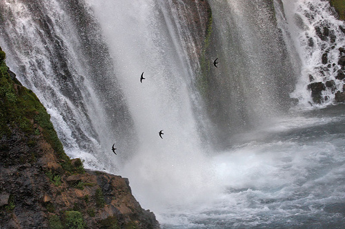
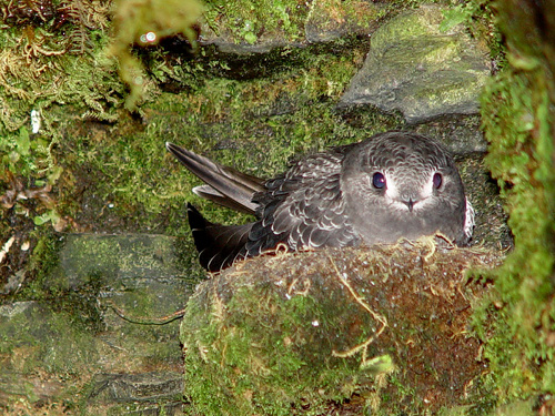
The black swift (Cypseloides niger) leads a secretive life. These small, sleek birds are rare to begin with, and their numbers appear to be declining due to climate change and habitat loss. They live in remote locations, choosing to nest high on wet cliff faces, often behind waterfalls. This makes them a challenge to observe (they’re a prize on any birdwatcher’s list), and even more difficult to study. The biggest mystery about these birds was where they were spending the winter. They’ve long been recorded returning to the same nesting sites each spring, but no reliable winter observations had ever been made; they simply vanished, literally into thin air, for seven months every year. Given the extraordinary migrations of many bird species, they could have been wintering almost anywhere (and since this information is vital for conservation efforts, there is some urgency to this research). But this decades-old mystery was recently solved, thanks to highly-dedicated researchers, and some very clever engineering.
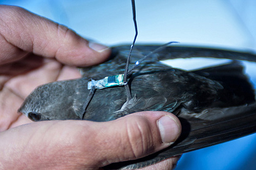
In 2009, at a nest site near Ouray, Colo., researchers from the Rocky Mountain Bird Observatory and US Forest Service captured four black swifts, fitted them with tiny datalogging backpacks, and released them back into the wild. Similar dataloggers had been used in the past by the British Antarctic Survey to study albatross, which may not return to dry land for years at a time. However, albatross are some of the world's largest birds; an urgent need to track smaller species drove an intense effort to shrink these devices, and it is only recently that they have been made small enough to be comfortably carried by diminutive birds such as the swift.
The following year the researchers returned to the nest site, and amazingly, managed to retrieve three of the four backpacks. When they downloaded and analyzed the data, for the first time in history they were able to follow the swift’s yearly migration to a remote area of the Brazilian rainforest. The researchers found that the birds log around 350km (217 miles) per day when they’re on the wing, travel 7000km (4350 miles) each way, and surprisingly, spend the winter in lowland rainforest, not the mountainous environments that they prefer during their summers in North America.
The study was a huge success, and the information gained will greatly help in conservation efforts for this bird. (And now that people know what to look for, there have even been a few possible sightings in their winter range.) What’s neat from an engineering perspective is the simplicity of the backpacks. Surprisingly, they do not use GPS. In fact, the backpacks have only one sensor, light level, along with a real-time clock. Can you guess how these two inputs are used to determine the bird’s location?
“Light-Level Geolocators” or “Geologgers” use the light sensor and real-time clock to record the times when sunrise and sunset occur locally each day. When (and if) the device is recovered, one can process the data to determine the approximate location of the bird on any logged date. Longitude (east-west location) is calculated from the time of the local sunrise and sunset; these will occur later the further west you travel. Latitude (north-south location) can be determined from the length of daylight, which will vary according to the location and time of year. The uncertainty is on the order of 300km (186 miles), which is a reasonable number in this field, especially considering that the simplicity of the design allows the creation of an instrument package weighing slightly more than a gram. Such a small device greatly increases the number of species that can be studied using this technique; for perspective, the black swift only weighs about 50 grams itself.
So what engineering lessons can we take from this?
When approaching complex problems, we'll often jump straight to complex solutions. For a tracking problem like this one, GPS has become such a go-to technology, you might not even consider other options. And, since most times you don't get the package back, you might decide that it's necessary to transmit real-time information using radio, GSM (cell phone) or even satellite modem. Once you've convinced yourself this is the right way to go, your task then turns into miniaturizing those components until they're (hopefully) small, light, rugged, and long-lived enough for the task at hand.
However, if you step back and honestly analyze what you actually need to do, distilling the task down to its bare essentials (this is known as "scrubbing the requirements"), take advantage of things the environment already gives you, and add a bit of interdisciplinary imagination; you might come up with an extremely elegant solution like this one. And maybe help some natives in the process.
Thank you to photographers Glen Tepke, Terry Gray, and Todd Patrick for their kind permission to include their work above.
More information:
"The Northern Black Swift: Migration Path And Wintering Area Revealed" Jason Beason, Carolyn Gunn, Kim Potter, Robert Sparks, and James W. Fox, Wilson Journal of Ornithology, March 2012 (abstract only, full text available for purchase)
"Birders take black swift mystery under their wing" Nancy Lofholm, The Denver Post, 3/5/2012
Black Swift Research Project and news story at the Rocky Mountain Bird Observatory
The Geologgers used in the black swift study were manufactured by Biotrack UK under license from the British Antarctic Survey (more detailed information here). The Migratory Connectivity Project has an overview of geologging and other tracking techniques, with a list of additional hardware and software manufacturers.
An overview of a software package (and technique) used to process raw tracking data: Jensen Software Systems MultiTrace
"A miniature daylight level and activity data recorder for tracking animals over long periods" Vsevolod Afanasyev, British Antarctic Survey (includes a schematic for a PIC-based geologger)
Requirements scrubbing from a software development perspective (but it works for all kind of things): Achieving Leaner Software, Steve McConnell
And check out this earlier SparkFun.com news post about a larger GSM-based project: Solar-Powered Bird Tracking


heck yes. love this
A great article to remind us that less is more when trying to reach engineering perfection. Reminds me of a quote by Antoine de Saint-Expury
"A designer knows he has achieved perfection not when there is nothing left to add, but when there is nothing left to take away."
Reminds me what my professors said, "Keep it simple, Stupid! Now, back to deriving Schrodinger's equation for a lattice structure of Silicon doped with Germanium."
also brings to mind one of my favorite of Rams' 10 principles: "Good design is as little design as possible"
Awesome "Backpack"! interesting read love seeing things like this!
Posts like this are why we love SparkFun!
Even I'll admit--working for Digi--not everything needs to be wireless.
Excellent article! I enjoyed it very much!
Thanks Mike, this post is fantastic!
Now, can anyone think of a way to use this technology in the Sparkfun AVC?
Great post. We all know there are tons of geeky technology out there, but seeing a really interesting application of some of that geekness is cool.
Read the first paragraph in the professor's voice(as I can't help but do with all of Mike's comments, and make sure to add "Good news, everyone!"), add to the end that they are going hunting on a strange planet, and BOOM Futurama episode.
But seriously, this is pretty cool. Those things probably cost 1/10th of what a GPS one would have.
This is a really great lesson to learn from that thinking outside the box is a great way to solve problems such as this.
This is soooo cool with the simplicity of the solution! This definitely falls under K.I.S.S.
This was really inspiring. Thanks, Mike!
Comment: That 2nd pic makes me hungry 4 swift... mmmmmmmm! :P
Simple and elegant. Very Cool! A family member of a friend of mine was seriously hurt years ago becuae he fell asleep while driving. Drove in to a corn field. My friends solution was to develop a micro powered system that used a compass and a drive shaft sensor and clever code. The unit could memorize routes and warn the driver of the above situation when it recognized that the driver usually slowed and stopped on that part of a route. GPS not required. Would like to work on such a system.
Great Article! A good creative solution. Thank you Glen, Terry and Tod.
Wow. They like tropical forest and high mountain water falls. Where will they over go with climate change? I wonder where they went last time?
The battery power is what I find really amazing. I hope I can design something so efficient.
Two good ways to do this are lowering the clock speed (for example PICs (edit: and AVRs) can be run down to 32kHz - note the k! - on the internal clock), and keep the chip in sleep mode as much as possible. Nate did a great tutorial on this: Adventures in Low Power Land.