Understanding GNSS Orbits
Check out our latest geospatial blog post - this time focusing on orbits, their uses, and which GNSS systems utilize them!

In our last blog, GPS vs GNSS, we covered the basics of how satellites function together to create usable geolocation devices. Note: If you haven't read that blog, do so before jumping into this one! This blog is going to go more in-depth into the different orbits GNSS's use, as well as other uses for these orbits.
So What's an Orbit?
An orbit is, by definition, the curved path of a celestial object or spacecraft around a star, planet, or moon, especially a periodic elliptical revolution. The following text is formatted to give you:
- A definition of each orbit and...
- A summary of which GNSS systems use that orbit in the form of (SPACE ORBIT - Country (Satellite #)), or in layman's terms, what are the orbits called, who uses them, and how many satellites there are.
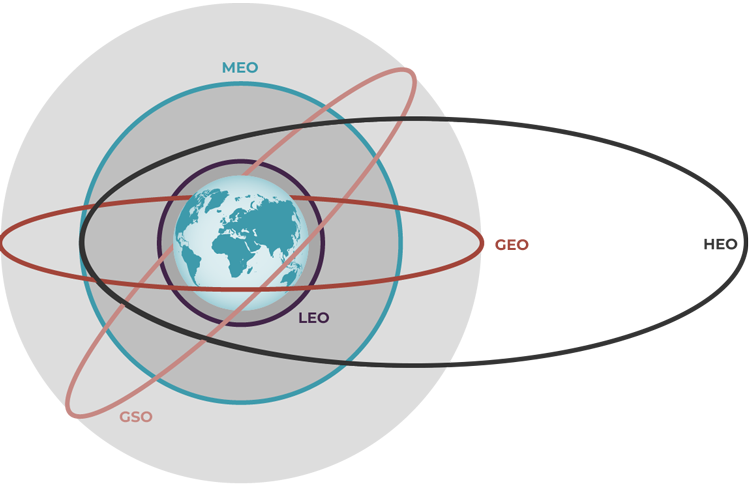
Geosychronous and Geostationary Orbit (GSO/GEO) - China(3), Japan (1)
- Altitude: 35,786 km and up
- Speed: 3 km/sec
- Orbital Period: 24 hours
- Uses: Communication Satellites, Broadcast Satellites
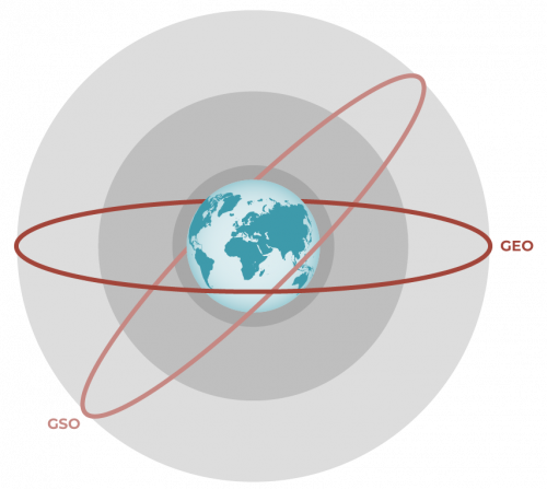
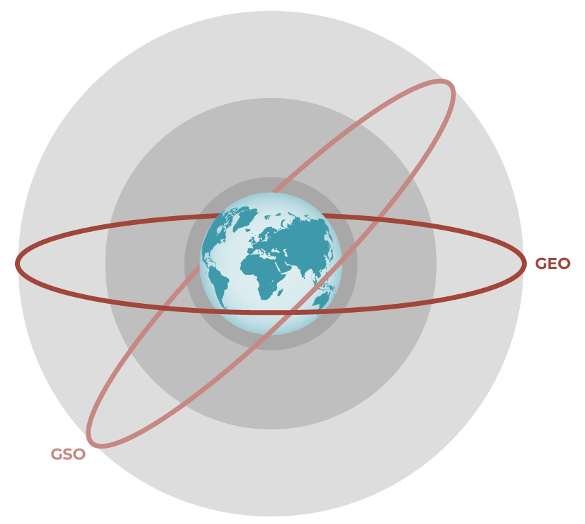
GSO vs GEO
GSO and GEO each have a speed of orbit that matches the earth's rotation. This means GEO is a type of GSO. The difference between the two is that GEO only orbits along the same plane as the earth's equator.
Both GSO and GEO are circular orbits 35,786 kilometers (22,236 miles) in altitude above Earth's Equator (42,164 kilometers in radius from Earth's center) and follows the direction of Earth's rotation. Since it takes this orbit roughly 24 hours to move around the Earth, satellites in a GEO will appear as a fixed position in the sky.
The BeiDou Navigation Satellite System (BDS) consists of a number of satellites located in the Geostationary Earth Orbit. The BeiDou-1 network covers most areas of the East Asia region and has both navigation and communication functions. The system does not require a large constellation of satellites, but limits the coverage to areas on Earth where the satellites are visible.
Medium Earth Orbit (MEO) - China (24), USA (29), Galileo (30), GLONASS (24), IRNSS (8)
- Altitude: 2000-35,786 km
- Speed: 3-8 km/sec
- Orbital Period: 2-24 hours
- Uses: GPS and Other Navigation Applications

GPS satellites fly in medium Earth orbit (MEO) at an altitude of approximately 20,200 km (12,550 miles). Each satellite circles the Earth twice a day. The satellites in the GPS constellation are arranged into six equally-spaced orbital planes surrounding the Earth, and every plane contains four "slots" occupied by baseline satellites. This 24-slot arrangement ensures users can view at least four satellites from virtually any point on the planet. While it is true that most GNSS orbits fall into MEO, this is not true across the board.
Most of what we make here at SparkFun lives in the MEO range with a majority of our product focused on knowing your position on earth.
Looking to get your hands on GPS/GNSS hardware?
View our line of breakout boards, RTK surveyors, antennas and more to outfit your next GPS/GNSS project.
Find Your Hardware
Low Earth Orbit (LEO) - (Hubble, Iridium, International Space Station)
- Altitude: 160-2000 km
- Speed: 8 km/sec
- Orbital Period: 24+ hrs
- Uses: Military Reconnaissance, Voice and Data Services

A Low Earth Orbit (LEO) is an Earth-centered orbit near the planet, often specified as having a period of 128 minutes or less. Most of the artificial objects in outer space are in LEO, with an altitude never more than about one-third of the radius of Earth. LEO is used for the area of space below an altitude of 2,000 km. One of the latest and most ambitious project in the LEO range is SpaceX's Starlink mission. Starlink aims to launch thousands of satellites into LEO to bring high speed internet to all parts of the world.
Highly Elliptical Orbit (HEO)
- Altitude: up to 40,000 km, as low as 1 km
- Speed: 1.5-10 km/sec
- Orbital Period: variable
- Uses: Communications, Satellite radio, Remote sensing

Satellites on a Highly Elliptial Orbit (HEO) are on an orbit with more of an oblong shape. The orbit will be much closer to the Earth on one end than the other. This makes it possible for a single satellite to have both with one end nearer the Earth and the other end more distant. It is also called molniya orbit.
Hopefully this blog has expanded your knowledge of orbits, as well as provided some of the basic info about what GNSS systems implement which orbits and with what number of satellites occupy those orbits. Check back in on the blog for more exciting product news and educational content!


Great, thank you for this information, I just enjoyed it and discovered the HEO. But please correct the minimum distance of 1 km. Otherwise we will have to wear helmets :-D
An amusing tidbit: All satellites experience some "drag", with the lower ones experiencing a lot more than those further up. This drag causes an orbital decay rate, which physicists express as an accelerationl, that is, a unit distance per square of a time unit. I've heard that the orbital decay rate for GEO orbits is almost exactly 1 furlong per fortnight squared.
For reference, a furlong is 1/8 mile or 220 yards. A fortnight is 14 days.
I'll also mention that very dense objects in very high orbits, such as the Moon, experience tidal forces that are greater than the drag, so experience acceleration rather than orbital decay (assuming they're in "prograde" orbits, i.e., orbiting in more-or-less the same direction as the Earth's rotation). Thus the Moon is slowly moving away from the Earth -- the calculations that got Neil Armstrong, et al, to the Moon would have to be redone to get them there safely today.