High Altitude Balloon Project
How to launch a helium balloon to 100,000 feet and take a picture of the curvature of the earth. And then lose the whole contraption out in a wheat field somewhere unknown.

Quick reminder: PTH Soldering Class tomorrow (July 7th). Join us and learn the basics of soldering by putting together the through-hole version of Simon. A great class for beginners!
Take a 7-foot diameter helium balloon, a box of electronics, and let them go. What do you get?
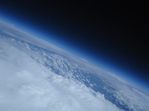
Space! Well, almost. At 100,000ft (30km) and -50C, it feels awful close.

We've written a rather large tutorial set that documents ultimate failure - I lost the balloon and all the electronics! It's currently sitting somewhere in the plains of eastern Colorado. Learn from our mistake and checkout the High Altitude Balloon intro and the Sensor System, Flight Computer, and Radio System tutorial. We'll get the next tutorial in the set posted next week so check back.


That sucks nate, maybe your next competition should be UAV package finding, whoever finds it with a rover/uav keeps everything but the pics ;)
I would happily exchange the electronics for the multiple SD cards inside. That is, unless you've already found it and holding it for ransom ;)
So I am doing a high altitude project and i am wanting to do something a little different so I will be launching an estes rocket that is hanging below the balloon once it reaches it's burst altitude but I can't figure out how to ignite the rocket. Any suggestions?
Ignoring the logistical and trajectory issues for that... I believe you can just use a normal igniter. Look up videos online of people firing Estes motors underwater.
We just successfully launched a high altitude balloon and recovered the capsule. The balloon reached 89,000 feet and we were able track it's progress the entire way using the Xtend modem.
Details of the project are here http://highaltballoon.com
Regading spin stablization; this is outside my area of knowledge but I wonder if some vertical 'fins' along each side if the payload would help. Yes, this would make it more vulnerable to wind but is that really a problem?
You might want to check out http://www.unr.edu/nevadasat/hale/ for a description of high-altitude balloon experiment performed in 2008. A group of LEGO Mindstorms enthusiasts launched two balloons containing a total of nine LEGO NXT systems and reached 99.5K foot altitude.
This sounds like a bit of an unanticipated antimov entry to me! hahaha.
Nate, check this
http://www.vwlowen.co.uk/java/horizon.htm
to calculate radio foot print.
60000' can be heard from 350 miles if you have the "big ears" on the ground to get that signal. Yagis, low noise preamps etc - all the stuff amateurs use to chat on satellites sub 1 watt over several thousand miles line of sitght.
TX power at the balloon can be quite low... 300mw on 144.390MHz. As long as you don't need to communicate with the payload for such things as triggering a cut down the power budget which translates into weight of batteries is a bigger consideration.
a 3 hour flight should give you 90,000' ( 1000'/min going up ) we have found little concern for keeping things warm up there. No convection will keep things warm. Camera batteries seem to heat the most snapping pictures every 15 seconds will get nice and toasty.
Alan VE4YZ
Excellent Nate!
I read from your profile that your are fluent in 2 languages. The seconds is the most important and now you have another challenge... document the GPS receivers you have on SparkFun and note whether they do 60,000' and/or 100k as long as only one of those parameters are violated - 60k feet.
But we mere mortals have to dig deeply through those datasheets to find those that will work for us on HAB.
Much success on future launches.
Alan VE4YZ
Nate,
Would you have the extra battery power to spin up a couple of gyros to help stabilize the cargo pod from yaw and pitch while pictures are being taken at the "top o' the world?" Seems like every motion picture I've seen taken from one of these balloons the cargo pod is spinning like a top. Would having some means of damping these oscillations produce better photos? What shutter speeds does one use at 100,000 ft?
In all of my HAB Googling, I found out something that I found interesting. A website that recorded a HAB project explained (in not to much detail) that fins positioned on the outside (doh!) of the payload would help stabilize it. I imagine that the payload would then have to be made more aerodynamic than usual; a three foot length of 4 (or preferably 6) inch PVC might work.Unfortunately, I have since lost the link.
I'm now 100% sure that this would do any good but if anyone is willing to try it I'd love to hear what it did.
NXTreme: I'm now 100% sure...
Sorry, typo. Supposed to say "I'm NOT 100% sure...".
Re: gyros, stilldavid has been talking about this sort of thing since his launch. There are apparently Issues. You might try asking the folks in #highaltitude on Freenode what they think of the idea. :)
After the first launch I looked into this. I got as far as building a servo pan/tilt module that was self-righting with a stepper-based rotating base.
I picked up a few gyros to play with and found a couple things. One, they have to be spinning really fast to work, and second the flywheel needs to have a fair amount of mass before the effect is usable in any way. I might crack open my old physics textbook to see how feasible it is, but for the payload size/weight we're going for it looks pretty bleak.
You might consider a system to increase the angular moment of your payload - I've used a 6' fiberglass rod with light foam balls (think the kind shot out of pneumatic toy cannons), and it worked wonders - made a launch in 25mph wind bearable to watch on video. Keep in mind that momentum is a conserved vector quantity, though, so the more stable your launch, the better off you are - the increased moment only slows down the rate of change in your angular velocity.
Nate,
First off, sorry you couldn't retrieve your project. Second, nicely done, I like that you used the I2C sensors, I do have a question. Since I am working on a similar project. It is however limited to just data acquisition for a weather balloon.
My question is this; you used the BMP085 pressure sensor which is what I had intended to use until after some research into pressures at that altitude and the data sheet which says its range is 300hPa-1100hPa. Research indicated I needed to get down to around 100hPa or 1mBar. How did the BMP085 perform (I took it from the article you were streaming live info from the payload), did it bottom out?
Here is a graph from the pressure readings I logged with my flight. That's using the SCP1000, which is only rated down to 30kPa. It reported readings as low as 1kPa (10 mbar), but who knows how accurate they are outside of the datasheet specs, although the numbers look pretty valid. The flickr page has a link to a CSV of all data that I logged during the flight if you want to dissect it.
Hope this helps!
I fly high altitude rockets - and we have several common issues with HAB - measurement. Some thoughts from my experience:
1. Your baro sensor does not have the range for high altitude. Your last measurement was about at the minimum pressure for the sensor. Check out the pressure range for these flights. There are other sensors available that have the range (and are appropriately temperature compensated) for this kind of flight.
2. Most commercial GPS chipsets simply will not work about 60k' MSL. Most Trimble and uBlox chipsets can bet set in a "flight" or "air" mode that is appropriate for flight. Use what works.
3. I have used the Digi radios that you used ... and have gotten much better range in the air. Something tells me you have either a configuration or antenna problem. That being said, I would use an off the shelf HAM based APRS tracker as your primary recovery system ... use the Digi as a higher performance secondary system.
Nice photo. I took my first high altitude balloon photo like this in 1987. This was before GPS and all the cool modules that SparkFun offers. When I developed the film at Walmart, the photo tech asked me, "Are you an Astronaut?".
Since my first flight in 1987, many groups have been active around the World. I now have flown about 400 flights and have become a Top 500 Spark Fun customer from buying all your modules that I fly to the very edge of Space itself.
I've been test flying my design of an all-in-one GPS tracking transmitter that uses an Inventek GPS unit specifically designed to operate at high altitudes. Many GPS units will not work above 60,000 feet...more info at: http://www.elktronics.com or http://www.wb8elk.com
With the advent of program hacks like CHDK for the Canon Powershot series of digital cameras along with inexpensive and lightweight camcorders, it's easy now to take amazing photos and videos like the one that SparkFun took here. The tricky part is getting it all back in one piece. That's where GPS tracking equipment will save the day.
I'd love to help out for your next HAB balloon flight.
- Bill Brown (amateur radio call: WB8ELK)
"Are you an Astronaut?".
i lold a lot.
That is why we went with the Trimble Copernicus module. When put into AIR MODE, it's good for well over the usual 60K feet mark that most units top out at.
I have been using the sparkfun Venus breakout board (GPS-09133) without problems. I choose it because the documentation specifically says it works above 60K feet as long as you stay under the 1000MPH limit.
Im the wrong side of the pond and my UAV wont make it that far yet ;)
A lot of folks have been doing this kind of thing for a long time (since before GPS). Check out http://showcase.netins.net/web/wallio/GPSrcvrsvs60kft.htm for a list of GPS receivers currently tested for high-altitude ops, and http://nearspaceventures.com/gpsl2009/ for information on the Great Plains Super Launch - an awesome gathering of some of the most experienced Amateur HAB groups in the country. Also, Sparkfun is near one of the groups involved: check out http://www.eoss.org/, based in Denver and Longmont.
Hey Dave! I talked with Rick from EOSS before launching, and he was extremely helpful and had tons of information. It's easy to see that they've been at it a long time!
I'm really bummed but I've got other plans during GPSL 2010 already, but I'm definitely going next year!
73s KI6YMZ
You needed one of our RTrak-HAP (High Altitude Package) APRS trackers on the balloon so you knew where it came down:
http://rpc-electronics.com/img/rtrak/hap/dscf2358.jpg
http://rpc-electronics.com/img/rtrak/hap/dscf2365.jpg