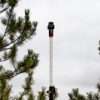
Today Point One Nav is officially launching support for GIS product creators, surveyors, and GIS professionals on the Polaris RTK Network. To reach centimeter level accuracy, they’ve invented automatic assignment of datums and base stations. You connect to a single mount point, one time, and they make sure your devices are referencing the closest base stations and the appropriate local datum.
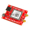
In the video below, Point One shows how Polaris brings survey-grade precision to the Sparkfun RTK Facet. You can connect to Point One’s centimeter-accurate network in minutes - no more slogging through complicated credentials!
Connect to a single mount point and Point One’s Polaris RTK network intelligently assigns you to the closest base station and provides results in the relevant datum for your continent or country. You can access survey-grade RTK through your Sparkfun RTK Facet, untethered by constraints of geography or region. Additionally, Point One’s GraphQL API takes an afternoon to integrate with your device.
They're even offering a free trial right now for this new RTK tech, and you can sign up on their website.


